You are here: Home > Network List > AV - Alaska Volcano Observatory Stations List
> Station AMKA Regional Station, Amchitka Island, Alaska > Earthquake Result Viewer
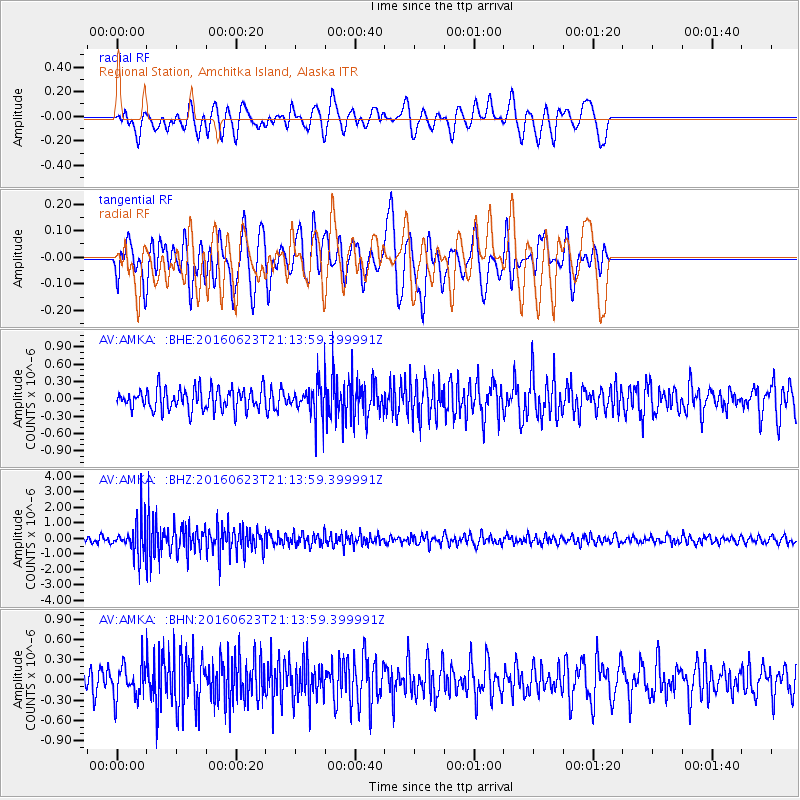
AMKA Regional Station, Amchitka Island, Alaska - Earthquake Result Viewer
*The percent match for this event was below the threshold and hence no stack was calculated.
| Earthquake location: |
Southwestern Ryukyu Isl., Japan |
| Earthquake latitude/longitude: |
23.6/123.4 |
| Earthquake time(UTC): |
2016/06/23 (175) 21:05:29 GMT |
| Earthquake Depth: |
10 km |
| Earthquake Magnitude: |
5.9 MWP |
| Earthquake Catalog/Contributor: |
NEIC PDE/NEIC COMCAT |
|
| Network: |
AV Alaska Volcano Observatory |
| Station: |
AMKA Regional Station, Amchitka Island, Alaska |
| Lat/Lon: |
51.38 N/179.30 E |
| Elevation: |
116 m |
|
| Distance: |
50.8 deg |
| Az: |
42.081 deg |
| Baz: |
258.765 deg |
| Ray Param: |
$rayparam |
*The percent match for this event was below the threshold and hence was not used in the summary stack. |
|
| Radial Match: |
61.20972 % |
| Radial Bump: |
400 |
| Transverse Match: |
47.213615 % |
| Transverse Bump: |
400 |
| SOD ConfigId: |
7422571 |
| Insert Time: |
2019-04-22 21:55:57.813 +0000 |
| GWidth: |
2.5 |
| Max Bumps: |
400 |
| Tol: |
0.001 |
|
Signal To Noise
| Channel | StoN | STA | LTA |
| AV:AMKA: :BHZ:20160623T21:13:59.399991Z | 5.696002 | 1.0583682E-6 | 1.8580894E-7 |
| AV:AMKA: :BHN:20160623T21:13:59.399991Z | 1.3681617 | 2.5028444E-7 | 1.8293484E-7 |
| AV:AMKA: :BHE:20160623T21:13:59.399991Z | 1.3277025 | 2.4035145E-7 | 1.810281E-7 |
| Arrivals |
| Ps | |
| PpPs | |
| PsPs/PpSs | |


