You are here: Home > Network List > KN - Kyrgyz Seismic Telemetry Network Stations List
> Station UCH - > Earthquake Result Viewer
UCH - - Earthquake Result Viewer
| Earthquake location: |
Southwestern Ryukyu Isl., Japan |
| Earthquake latitude/longitude: |
23.6/123.4 |
| Earthquake time(UTC): |
2016/06/23 (175) 21:05:29 GMT |
| Earthquake Depth: |
10 km |
| Earthquake Magnitude: |
5.9 MWP |
| Earthquake Catalog/Contributor: |
NEIC PDE/NEIC COMCAT |
|
| Network: |
KN Kyrgyz Seismic Telemetry Network |
| Station: |
UCH - |
| Lat/Lon: |
42.23 N/74.51 E |
| Elevation: |
3850 m |
|
| Distance: |
44.4 deg |
| Az: |
306.87 deg |
| Baz: |
98.895 deg |
| Ray Param: |
0.0719569 |
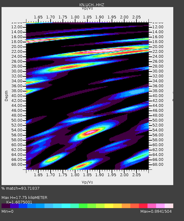
| Estimated Moho Depth: |
17.75 km |
| Estimated Crust Vp/Vs: |
1.61 |
| Assumed Crust Vp: |
6.306 km/s |
| Estimated Crust Vs: |
3.923 km/s |
| Estimated Crust Poisson's Ratio: |
0.18 |
|
| Radial Match: |
93.71837 % |
| Radial Bump: |
390 |
| Transverse Match: |
84.02393 % |
| Transverse Bump: |
400 |
| SOD ConfigId: |
7422571 |
| Insert Time: |
2019-04-22 21:57:57.018 +0000 |
| GWidth: |
2.5 |
| Max Bumps: |
400 |
| Tol: |
0.001 |
|
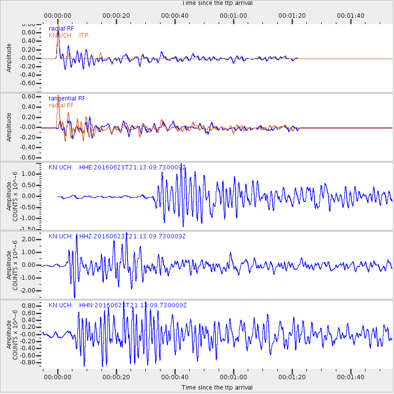
Signal To Noise
| Channel | StoN | STA | LTA |
| KN:UCH: :HHZ:20160623T21:13:09.730009Z | 5.565815 | 4.6234487E-7 | 8.306867E-8 |
| KN:UCH: :HHN:20160623T21:13:09.730009Z | 1.5358135 | 6.685935E-8 | 4.3533507E-8 |
| KN:UCH: :HHE:20160623T21:13:09.730009Z | 5.5981727 | 1.9266021E-7 | 3.441484E-8 |
| Arrivals |
| Ps | 1.8 SECOND |
| PpPs | 6.8 SECOND |
| PsPs/PpSs | 8.7 SECOND |


