You are here: Home > Network List > TA - USArray Transportable Network (new EarthScope stations) Stations List
> Station G23K Bananza Creek, AK, USA > Earthquake Result Viewer
G23K Bananza Creek, AK, USA - Earthquake Result Viewer

| Earthquake location: |
Southwestern Ryukyu Isl., Japan |
| Earthquake latitude/longitude: |
23.6/123.4 |
| Earthquake time(UTC): |
2016/06/23 (175) 21:05:29 GMT |
| Earthquake Depth: |
10 km |
| Earthquake Magnitude: |
5.9 MWP |
| Earthquake Catalog/Contributor: |
NEIC PDE/NEIC COMCAT |
|
| Network: |
TA USArray Transportable Network (new EarthScope stations) |
| Station: |
G23K Bananza Creek, AK, USA |
| Lat/Lon: |
66.71 N/150.02 W |
| Elevation: |
746 m |
|
| Distance: |
67.2 deg |
| Az: |
25.499 deg |
| Baz: |
276.747 deg |
| Ray Param: |
0.057097778 |
| Estimated Moho Depth: |
29.0 km |
| Estimated Crust Vp/Vs: |
1.82 |
| Assumed Crust Vp: |
6.577 km/s |
| Estimated Crust Vs: |
3.609 km/s |
| Estimated Crust Poisson's Ratio: |
0.28 |
|
| Radial Match: |
91.815544 % |
| Radial Bump: |
400 |
| Transverse Match: |
83.71533 % |
| Transverse Bump: |
400 |
| SOD ConfigId: |
7422571 |
| Insert Time: |
2019-04-22 21:59:30.062 +0000 |
| GWidth: |
2.5 |
| Max Bumps: |
400 |
| Tol: |
0.001 |
|
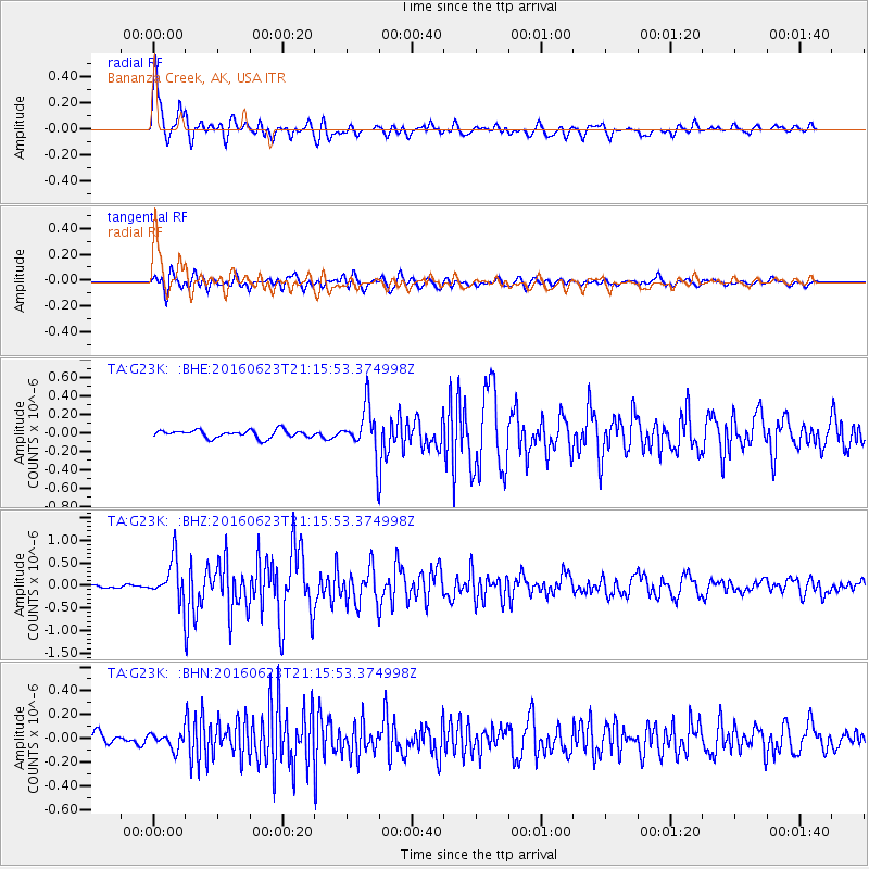
Signal To Noise
| Channel | StoN | STA | LTA |
| TA:G23K: :BHZ:20160623T21:15:53.374998Z | 6.7344217 | 4.4899636E-7 | 6.667185E-8 |
| TA:G23K: :BHN:20160623T21:15:53.374998Z | 1.6116974 | 6.445816E-8 | 3.999396E-8 |
| TA:G23K: :BHE:20160623T21:15:53.374998Z | 4.99206 | 2.101822E-7 | 4.21033E-8 |
| Arrivals |
| Ps | 3.8 SECOND |
| PpPs | 12 SECOND |
| PsPs/PpSs | 16 SECOND |


