You are here: Home > Network List > TA - USArray Transportable Network (new EarthScope stations) Stations List
> Station J25K Salcha River, AK, USA > Earthquake Result Viewer
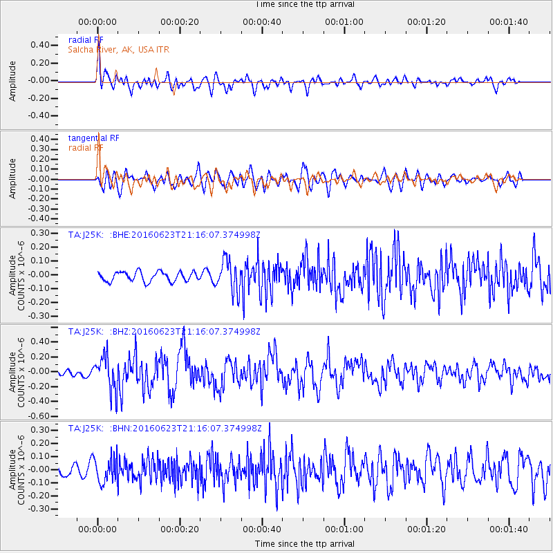
J25K Salcha River, AK, USA - Earthquake Result Viewer
*The percent match for this event was below the threshold and hence no stack was calculated.
| Earthquake location: |
Southwestern Ryukyu Isl., Japan |
| Earthquake latitude/longitude: |
23.6/123.4 |
| Earthquake time(UTC): |
2016/06/23 (175) 21:05:29 GMT |
| Earthquake Depth: |
10 km |
| Earthquake Magnitude: |
5.9 MWP |
| Earthquake Catalog/Contributor: |
NEIC PDE/NEIC COMCAT |
|
| Network: |
TA USArray Transportable Network (new EarthScope stations) |
| Station: |
J25K Salcha River, AK, USA |
| Lat/Lon: |
64.61 N/145.37 W |
| Elevation: |
949 m |
|
| Distance: |
69.5 deg |
| Az: |
27.402 deg |
| Baz: |
281.687 deg |
| Ray Param: |
$rayparam |
*The percent match for this event was below the threshold and hence was not used in the summary stack. |
|
| Radial Match: |
75.262794 % |
| Radial Bump: |
400 |
| Transverse Match: |
65.21595 % |
| Transverse Bump: |
400 |
| SOD ConfigId: |
7422571 |
| Insert Time: |
2019-04-22 21:59:41.130 +0000 |
| GWidth: |
2.5 |
| Max Bumps: |
400 |
| Tol: |
0.001 |
|
Signal To Noise
| Channel | StoN | STA | LTA |
| TA:J25K: :BHZ:20160623T21:16:07.374998Z | 4.11908 | 2.3148179E-7 | 5.6197447E-8 |
| TA:J25K: :BHN:20160623T21:16:07.374998Z | 3.096164 | 9.416738E-8 | 3.041421E-8 |
| TA:J25K: :BHE:20160623T21:16:07.374998Z | 3.329802 | 1.1563563E-7 | 3.4727478E-8 |
| Arrivals |
| Ps | |
| PpPs | |
| PsPs/PpSs | |


