You are here: Home > Network List > TJ - Tajikistan National Seismic Network Stations List
> Station GARM Garm, Tajikistan > Earthquake Result Viewer
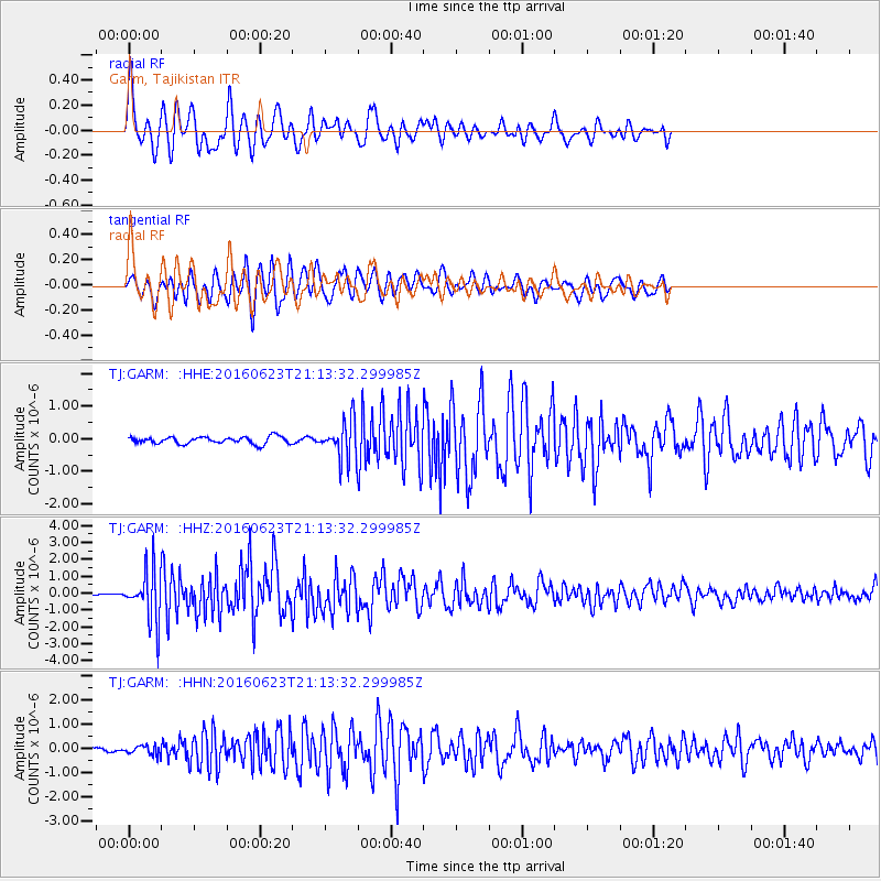
GARM Garm, Tajikistan - Earthquake Result Viewer
*The percent match for this event was below the threshold and hence no stack was calculated.
| Earthquake location: |
Southwestern Ryukyu Isl., Japan |
| Earthquake latitude/longitude: |
23.6/123.4 |
| Earthquake time(UTC): |
2016/06/23 (175) 21:05:29 GMT |
| Earthquake Depth: |
10 km |
| Earthquake Magnitude: |
5.9 MWP |
| Earthquake Catalog/Contributor: |
NEIC PDE/NEIC COMCAT |
|
| Network: |
TJ Tajikistan National Seismic Network |
| Station: |
GARM Garm, Tajikistan |
| Lat/Lon: |
39.00 N/70.32 E |
| Elevation: |
1305 m |
|
| Distance: |
47.2 deg |
| Az: |
301.947 deg |
| Baz: |
92.736 deg |
| Ray Param: |
$rayparam |
*The percent match for this event was below the threshold and hence was not used in the summary stack. |
|
| Radial Match: |
76.32009 % |
| Radial Bump: |
400 |
| Transverse Match: |
81.83244 % |
| Transverse Bump: |
400 |
| SOD ConfigId: |
7422571 |
| Insert Time: |
2019-04-22 22:00:20.655 +0000 |
| GWidth: |
2.5 |
| Max Bumps: |
400 |
| Tol: |
0.001 |
|
Signal To Noise
| Channel | StoN | STA | LTA |
| TJ:GARM: :HHZ:20160623T21:13:32.299985Z | 17.777655 | 1.5102241E-6 | 8.495069E-8 |
| TJ:GARM: :HHN:20160623T21:13:32.299985Z | 2.5321622 | 1.8800631E-7 | 7.424734E-8 |
| TJ:GARM: :HHE:20160623T21:13:32.299985Z | 5.3300815 | 5.593212E-7 | 1.0493672E-7 |
| Arrivals |
| Ps | |
| PpPs | |
| PsPs/PpSs | |


