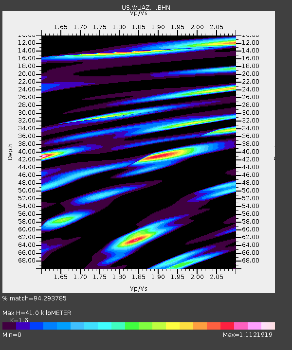
WUAZ Wupatki, Arizona, USA - Earthquake Result Viewer
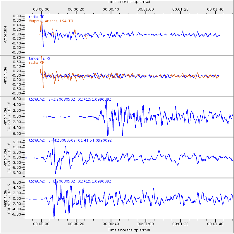
Earthquake location: Andreanof Islands, Aleutian Is.
Earthquake latitude/longitude: 51.9/-177.5
Earthquake time(UTC): 2008/05/02 (123) 01:33:37 GMT
Earthquake Depth: 14 km
Earthquake Magnitude: 6.3 MB, 6.8 MS, 6.6 MW, 6.6 MW
Earthquake Catalog/Contributor: WHDF/NEIC
Network: US United States National Seismic Network
Station: WUAZ Wupatki, Arizona, USA
Lat/Lon: 35.52 N/111.37 W
Elevation: 1592 m
Distance: 48.8 deg
Az: 82.374 deg
Baz: 311.114 deg
Ray Param: 0.06908702
Estimated Moho Depth: 41.0 km
Estimated Crust Vp/Vs: 1.60
Assumed Crust Vp: 6.207 km/s
Estimated Crust Vs: 3.879 km/s
Estimated Crust Poisson's Ratio: 0.18
Radial Match: 94.293785 %
Radial Bump: 400
Transverse Match: 83.27964 %
Transverse Bump: 400
SOD ConfigId: 2504
Insert Time: 2010-03-05 04:52:00.437 +0000
GWidth: 2.5
Max Bumps: 400
Tol: 0.001

Signal To Noise

ChannelStoNSTALTA
US:WUAZ: :BHN:20080502T01:41:51.099009Z13.5410571.4338272E-61.0588739E-7
US:WUAZ: :BHE:20080502T01:41:51.099009Z11.6762177.8875684E-76.755243E-8
US:WUAZ: :BHZ:20080502T01:41:51.099009Z10.5954268.567946E-78.0864574E-8
Arrivals
Ps4.2 SECOND
PpPs16 SECOND
PsPs/PpSs20 SECOND