You are here: Home > Network List > N4 - Central and EAstern US Network Stations List
> Station T45B Paducah, KY, USA > Earthquake Result Viewer
T45B Paducah, KY, USA - Earthquake Result Viewer
| Earthquake location: |
Northern Chile |
| Earthquake latitude/longitude: |
-25.7/-69.3 |
| Earthquake time(UTC): |
2016/06/24 (176) 21:29:18 GMT |
| Earthquake Depth: |
122 km |
| Earthquake Magnitude: |
5.5 MB |
| Earthquake Catalog/Contributor: |
NEIC PDE/NEIC COMCAT |
|
| Network: |
N4 Central and EAstern US Network |
| Station: |
T45B Paducah, KY, USA |
| Lat/Lon: |
37.02 N/88.65 W |
| Elevation: |
136 m |
|
| Distance: |
65.0 deg |
| Az: |
343.029 deg |
| Baz: |
160.799 deg |
| Ray Param: |
0.058206975 |
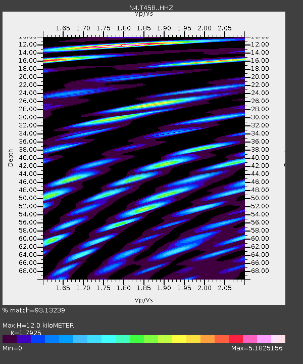
| Estimated Moho Depth: |
12.0 km |
| Estimated Crust Vp/Vs: |
1.79 |
| Assumed Crust Vp: |
6.444 km/s |
| Estimated Crust Vs: |
3.595 km/s |
| Estimated Crust Poisson's Ratio: |
0.27 |
|
| Radial Match: |
93.13239 % |
| Radial Bump: |
400 |
| Transverse Match: |
63.4715 % |
| Transverse Bump: |
400 |
| SOD ConfigId: |
7422571 |
| Insert Time: |
2019-04-22 22:06:42.324 +0000 |
| GWidth: |
2.5 |
| Max Bumps: |
400 |
| Tol: |
0.001 |
|

Signal To Noise
| Channel | StoN | STA | LTA |
| N4:T45B: :HHZ:20160624T21:39:15.829985Z | 4.83182 | 9.610918E-7 | 1.9890885E-7 |
| N4:T45B: :HHN:20160624T21:39:15.829985Z | 8.211217 | 1.8627389E-6 | 2.2685298E-7 |
| N4:T45B: :HHE:20160624T21:39:15.829985Z | 3.0789578 | 6.8731663E-7 | 2.2323029E-7 |
| Arrivals |
| Ps | 1.5 SECOND |
| PpPs | 5.0 SECOND |
| PsPs/PpSs | 6.5 SECOND |


