You are here: Home > Network List > CI - Caltech Regional Seismic Network Stations List
> Station SHO Shoshone, CA, USA > Earthquake Result Viewer
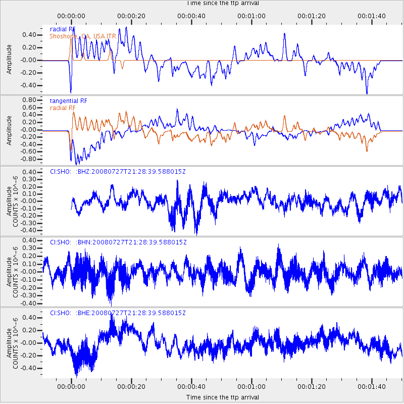
SHO Shoshone, CA, USA - Earthquake Result Viewer
*The percent match for this event was below the threshold and hence no stack was calculated.
| Earthquake location: |
Central Mid-Atlantic Ridge |
| Earthquake latitude/longitude: |
-0.3/-18.3 |
| Earthquake time(UTC): |
2008/07/27 (209) 21:15:41 GMT |
| Earthquake Depth: |
10 km |
| Earthquake Magnitude: |
5.8 MB, 5.3 MS, 5.9 MW, 5.8 MW |
| Earthquake Catalog/Contributor: |
WHDF/NEIC |
|
| Network: |
CI Caltech Regional Seismic Network |
| Station: |
SHO Shoshone, CA, USA |
| Lat/Lon: |
35.90 N/116.28 W |
| Elevation: |
451 m |
|
| Distance: |
96.6 deg |
| Az: |
305.958 deg |
| Baz: |
85.531 deg |
| Ray Param: |
$rayparam |
*The percent match for this event was below the threshold and hence was not used in the summary stack. |
|
| Radial Match: |
64.27217 % |
| Radial Bump: |
400 |
| Transverse Match: |
63.49193 % |
| Transverse Bump: |
400 |
| SOD ConfigId: |
2504 |
| Insert Time: |
2010-02-26 00:31:12.639 +0000 |
| GWidth: |
2.5 |
| Max Bumps: |
400 |
| Tol: |
0.001 |
|
Signal To Noise
| Channel | StoN | STA | LTA |
| CI:SHO: :BHN:20080727T21:28:39.588015Z | 1.6935242 | 1.3658558E-7 | 8.065168E-8 |
| CI:SHO: :BHE:20080727T21:28:39.588015Z | 2.0616622 | 2.2546223E-7 | 1.0935944E-7 |
| CI:SHO: :BHZ:20080727T21:28:39.588015Z | 1.9566331 | 1.7078268E-7 | 8.728396E-8 |
| Arrivals |
| Ps | |
| PpPs | |
| PsPs/PpSs | |


