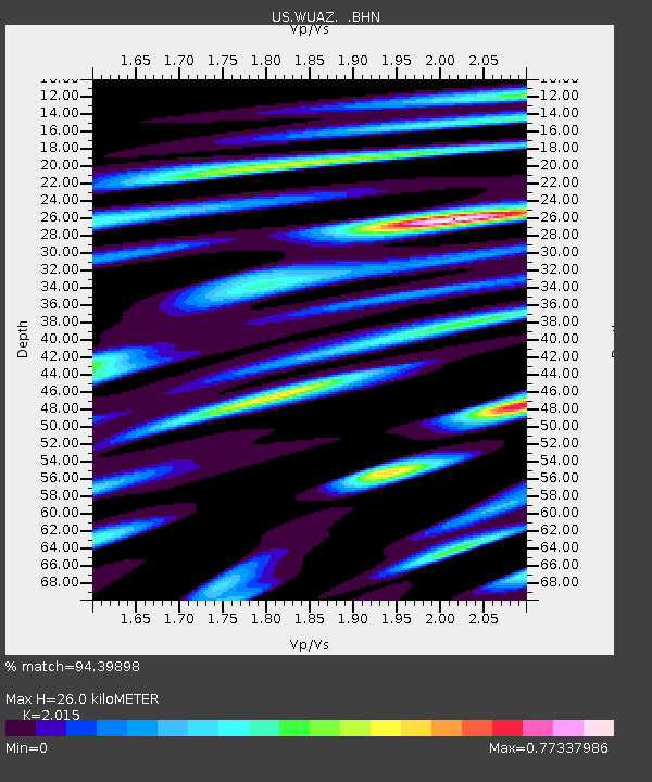
WUAZ Wupatki, Arizona, USA - Earthquake Result Viewer
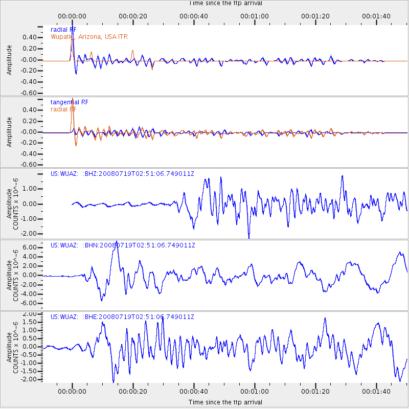
Earthquake location: Off East Coast Of Honshu, Japan
Earthquake latitude/longitude: 37.6/142.2
Earthquake time(UTC): 2008/07/19 (201) 02:39:28 GMT
Earthquake Depth: 22 km
Earthquake Magnitude: 6.2 MB, 7.0 MS, 7.0 MW, 6.9 MW
Earthquake Catalog/Contributor: WHDF/NEIC
Network: US United States National Seismic Network
Station: WUAZ Wupatki, Arizona, USA
Lat/Lon: 35.52 N/111.37 W
Elevation: 1592 m
Distance: 80.3 deg
Az: 52.542 deg
Baz: 309.344 deg
Ray Param: 0.048321944
Estimated Moho Depth: 26.0 km
Estimated Crust Vp/Vs: 2.02
Assumed Crust Vp: 6.207 km/s
Estimated Crust Vs: 3.08 km/s
Estimated Crust Poisson's Ratio: 0.34
Radial Match: 94.39898 %
Radial Bump: 400
Transverse Match: 81.35866 %
Transverse Bump: 400
SOD ConfigId: 2504
Insert Time: 2010-03-05 04:52:15.061 +0000
GWidth: 2.5
Max Bumps: 400
Tol: 0.001

Signal To Noise

ChannelStoNSTALTA
US:WUAZ: :BHN:20080719T02:51:06.749011Z3.66371873.0337313E-78.2804696E-8
US:WUAZ: :BHE:20080719T02:51:06.749011Z2.00583361.3458904E-76.709881E-8
US:WUAZ: :BHZ:20080719T02:51:06.749011Z1.24824139.980104E-87.995333E-8
Arrivals
Ps4.4 SECOND
PpPs12 SECOND
PsPs/PpSs17 SECOND