You are here: Home > Network List > CI - Caltech Regional Seismic Network Stations List
> Station SHO Shoshone, CA, USA > Earthquake Result Viewer
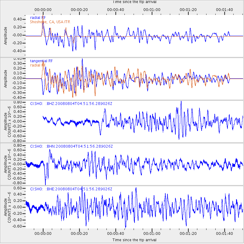
SHO Shoshone, CA, USA - Earthquake Result Viewer
*The percent match for this event was below the threshold and hence no stack was calculated.
| Earthquake location: |
Kuril Islands |
| Earthquake latitude/longitude: |
49.9/156.4 |
| Earthquake time(UTC): |
2008/08/04 (217) 04:42:14 GMT |
| Earthquake Depth: |
77 km |
| Earthquake Magnitude: |
5.6 MB, 5.8 MW, 5.7 MW |
| Earthquake Catalog/Contributor: |
WHDF/NEIC |
|
| Network: |
CI Caltech Regional Seismic Network |
| Station: |
SHO Shoshone, CA, USA |
| Lat/Lon: |
35.90 N/116.28 W |
| Elevation: |
451 m |
|
| Distance: |
62.0 deg |
| Az: |
66.705 deg |
| Baz: |
312.924 deg |
| Ray Param: |
$rayparam |
*The percent match for this event was below the threshold and hence was not used in the summary stack. |
|
| Radial Match: |
67.73066 % |
| Radial Bump: |
400 |
| Transverse Match: |
70.757996 % |
| Transverse Bump: |
400 |
| SOD ConfigId: |
2504 |
| Insert Time: |
2010-02-26 00:31:13.381 +0000 |
| GWidth: |
2.5 |
| Max Bumps: |
400 |
| Tol: |
0.001 |
|
Signal To Noise
| Channel | StoN | STA | LTA |
| CI:SHO: :BHN:20080804T04:51:56.289026Z | 5.5771646 | 3.774416E-7 | 6.7676254E-8 |
| CI:SHO: :BHE:20080804T04:51:56.289026Z | 1.0735298 | 1.11481214E-7 | 1.03845466E-7 |
| CI:SHO: :BHZ:20080804T04:51:56.289026Z | 3.2046947 | 2.683993E-7 | 8.3751914E-8 |
| Arrivals |
| Ps | |
| PpPs | |
| PsPs/PpSs | |


