You are here: Home > Network List > TA - USArray Transportable Network (new EarthScope stations) Stations List
> Station L44A Lake County Forest Preserve, Grayslake, IL, USA > Earthquake Result Viewer
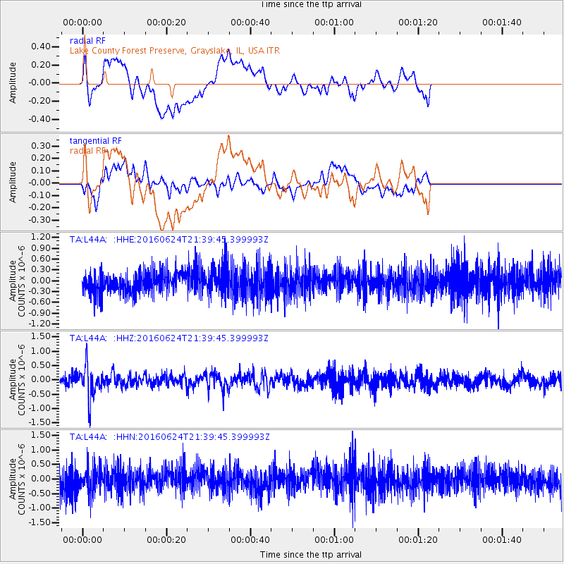
L44A Lake County Forest Preserve, Grayslake, IL, USA - Earthquake Result Viewer
*The percent match for this event was below the threshold and hence no stack was calculated.
| Earthquake location: |
Northern Chile |
| Earthquake latitude/longitude: |
-25.7/-69.3 |
| Earthquake time(UTC): |
2016/06/24 (176) 21:29:18 GMT |
| Earthquake Depth: |
122 km |
| Earthquake Magnitude: |
5.5 MB |
| Earthquake Catalog/Contributor: |
NEIC PDE/NEIC COMCAT |
|
| Network: |
TA USArray Transportable Network (new EarthScope stations) |
| Station: |
L44A Lake County Forest Preserve, Grayslake, IL, USA |
| Lat/Lon: |
42.18 N/87.91 W |
| Elevation: |
202 m |
|
| Distance: |
69.7 deg |
| Az: |
345.385 deg |
| Baz: |
162.172 deg |
| Ray Param: |
$rayparam |
*The percent match for this event was below the threshold and hence was not used in the summary stack. |
|
| Radial Match: |
39.759968 % |
| Radial Bump: |
400 |
| Transverse Match: |
43.484272 % |
| Transverse Bump: |
400 |
| SOD ConfigId: |
7422571 |
| Insert Time: |
2019-04-22 22:09:16.924 +0000 |
| GWidth: |
2.5 |
| Max Bumps: |
400 |
| Tol: |
0.001 |
|
Signal To Noise
| Channel | StoN | STA | LTA |
| TA:L44A: :HHZ:20160624T21:39:45.399993Z | 3.5076265 | 5.636078E-7 | 1.6068067E-7 |
| TA:L44A: :HHN:20160624T21:39:45.399993Z | 1.1461899 | 4.2956287E-7 | 3.747746E-7 |
| TA:L44A: :HHE:20160624T21:39:45.399993Z | 1.4088253 | 4.005973E-7 | 2.8434846E-7 |
| Arrivals |
| Ps | |
| PpPs | |
| PsPs/PpSs | |


