You are here: Home > Network List > TA - USArray Transportable Network (new EarthScope stations) Stations List
> Station Z41A Richland Creek Farm, El Dorado, AR, USA > Earthquake Result Viewer
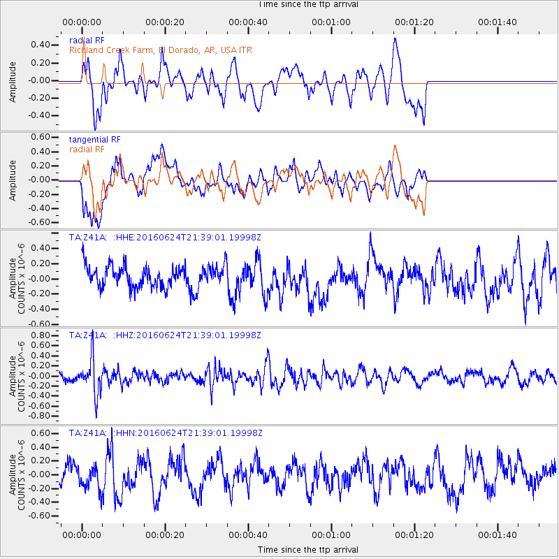
Z41A Richland Creek Farm, El Dorado, AR, USA - Earthquake Result Viewer
*The percent match for this event was below the threshold and hence no stack was calculated.
| Earthquake location: |
Northern Chile |
| Earthquake latitude/longitude: |
-25.7/-69.3 |
| Earthquake time(UTC): |
2016/06/24 (176) 21:29:18 GMT |
| Earthquake Depth: |
122 km |
| Earthquake Magnitude: |
5.5 MB |
| Earthquake Catalog/Contributor: |
NEIC PDE/NEIC COMCAT |
|
| Network: |
TA USArray Transportable Network (new EarthScope stations) |
| Station: |
Z41A Richland Creek Farm, El Dorado, AR, USA |
| Lat/Lon: |
33.26 N/92.80 W |
| Elevation: |
62 m |
|
| Distance: |
62.8 deg |
| Az: |
337.969 deg |
| Baz: |
156.187 deg |
| Ray Param: |
$rayparam |
*The percent match for this event was below the threshold and hence was not used in the summary stack. |
|
| Radial Match: |
62.313675 % |
| Radial Bump: |
400 |
| Transverse Match: |
63.153816 % |
| Transverse Bump: |
400 |
| SOD ConfigId: |
7422571 |
| Insert Time: |
2019-04-22 22:09:30.485 +0000 |
| GWidth: |
2.5 |
| Max Bumps: |
400 |
| Tol: |
0.001 |
|
Signal To Noise
| Channel | StoN | STA | LTA |
| TA:Z41A: :HHZ:20160624T21:39:01.19998Z | 4.486902 | 3.666622E-7 | 8.171833E-8 |
| TA:Z41A: :HHN:20160624T21:39:01.19998Z | 0.9196062 | 1.6281444E-7 | 1.7704801E-7 |
| TA:Z41A: :HHE:20160624T21:39:01.19998Z | 0.68989706 | 9.495774E-8 | 1.3764044E-7 |
| Arrivals |
| Ps | |
| PpPs | |
| PsPs/PpSs | |


