You are here: Home > Network List > G - GEOSCOPE Stations List
> Station MBO M'Bour, Senegal > Earthquake Result Viewer
MBO M'Bour, Senegal - Earthquake Result Viewer
| Earthquake location: |
South Sandwich Islands Region |
| Earthquake latitude/longitude: |
-58.6/-25.3 |
| Earthquake time(UTC): |
2019/04/09 (099) 17:53:59 GMT |
| Earthquake Depth: |
46 km |
| Earthquake Magnitude: |
6.5 Mww |
| Earthquake Catalog/Contributor: |
NEIC PDE/us |
|
| Network: |
G GEOSCOPE |
| Station: |
MBO M'Bour, Senegal |
| Lat/Lon: |
14.39 N/16.95 W |
| Elevation: |
3.0 m |
|
| Distance: |
73.0 deg |
| Az: |
8.435 deg |
| Baz: |
184.547 deg |
| Ray Param: |
0.053182196 |
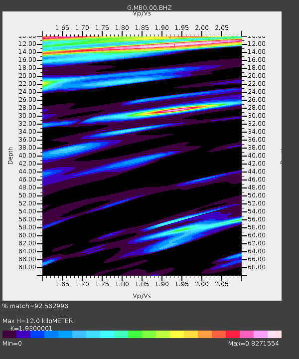
| Estimated Moho Depth: |
12.0 km |
| Estimated Crust Vp/Vs: |
1.93 |
| Assumed Crust Vp: |
5.55 km/s |
| Estimated Crust Vs: |
2.876 km/s |
| Estimated Crust Poisson's Ratio: |
0.32 |
|
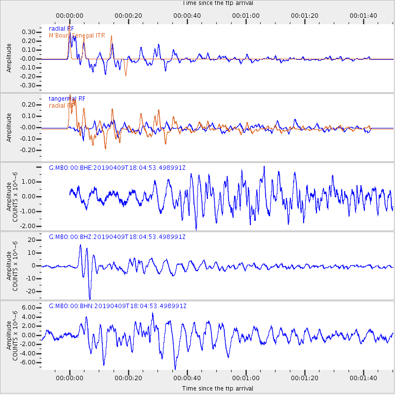
| Radial Match: |
92.562996 % |
| Radial Bump: |
374 |
| Transverse Match: |
77.75726 % |
| Transverse Bump: |
400 |
| SOD ConfigId: |
11735903 |
| Insert Time: |
2019-04-23 18:50:05.401 +0000 |
| GWidth: |
2.5 |
| Max Bumps: |
400 |
| Tol: |
0.001 |
|
Signal To Noise
| Channel | StoN | STA | LTA |
| G:MBO:00:BHZ:20190409T18:04:53.498991Z | 8.009854 | 5.882644E-6 | 7.344259E-7 |
| G:MBO:00:BHN:20190409T18:04:53.498991Z | 1.5481752 | 1.1362843E-6 | 7.339507E-7 |
| G:MBO:00:BHE:20190409T18:04:53.498991Z | 2.226218 | 7.6806265E-7 | 3.4500783E-7 |
| Arrivals |
| Ps | 2.1 SECOND |
| PpPs | 6.2 SECOND |
| PsPs/PpSs | 8.2 SECOND |


