You are here: Home > Network List > WI - West Indies IPGP Network Stations List
> Station BIM Morne Bigot, Anses d'Arlets, Martinique > Earthquake Result Viewer
BIM Morne Bigot, Anses d'Arlets, Martinique - Earthquake Result Viewer
| Earthquake location: |
South Sandwich Islands Region |
| Earthquake latitude/longitude: |
-58.6/-25.3 |
| Earthquake time(UTC): |
2019/04/09 (099) 17:53:59 GMT |
| Earthquake Depth: |
46 km |
| Earthquake Magnitude: |
6.5 Mww |
| Earthquake Catalog/Contributor: |
NEIC PDE/us |
|
| Network: |
WI West Indies IPGP Network |
| Station: |
BIM Morne Bigot, Anses d'Arlets, Martinique |
| Lat/Lon: |
14.52 N/61.07 W |
| Elevation: |
391 m |
|
| Distance: |
78.5 deg |
| Az: |
324.697 deg |
| Baz: |
161.791 deg |
| Ray Param: |
0.04951297 |
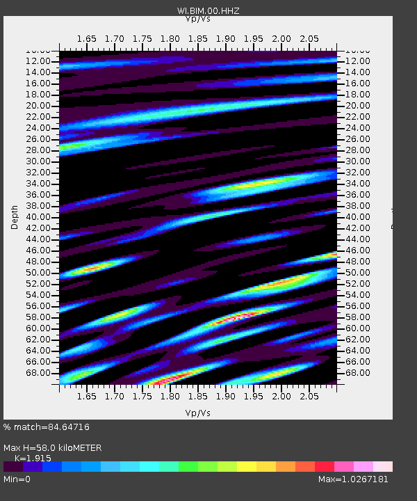
| Estimated Moho Depth: |
58.0 km |
| Estimated Crust Vp/Vs: |
1.91 |
| Assumed Crust Vp: |
5.88 km/s |
| Estimated Crust Vs: |
3.071 km/s |
| Estimated Crust Poisson's Ratio: |
0.31 |
|
| Radial Match: |
84.64716 % |
| Radial Bump: |
400 |
| Transverse Match: |
78.4977 % |
| Transverse Bump: |
400 |
| SOD ConfigId: |
11735903 |
| Insert Time: |
2019-04-23 18:51:36.418 +0000 |
| GWidth: |
2.5 |
| Max Bumps: |
400 |
| Tol: |
0.001 |
|
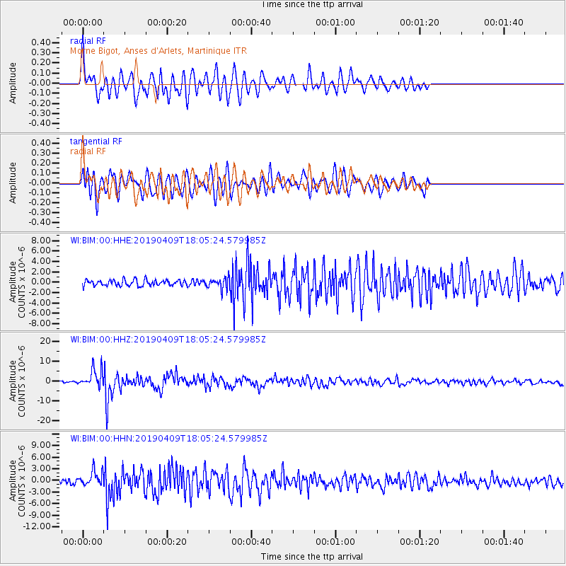
Signal To Noise
| Channel | StoN | STA | LTA |
| WI:BIM:00:HHZ:20190409T18:05:24.579985Z | 9.587077 | 4.6106356E-6 | 4.809219E-7 |
| WI:BIM:00:HHN:20190409T18:05:24.579985Z | 3.7919939 | 1.9441609E-6 | 5.127015E-7 |
| WI:BIM:00:HHE:20190409T18:05:24.579985Z | 1.871796 | 1.0395256E-6 | 5.5536265E-7 |
| Arrivals |
| Ps | 9.2 SECOND |
| PpPs | 28 SECOND |
| PsPs/PpSs | 37 SECOND |


