You are here: Home > Network List > AG - Arkansas Seismic Network Stations List
> Station U40A Yellville, AR > Earthquake Result Viewer
U40A Yellville, AR - Earthquake Result Viewer
| Earthquake location: |
Reykjanes Ridge |
| Earthquake latitude/longitude: |
53.9/-35.4 |
| Earthquake time(UTC): |
2016/06/25 (177) 17:54:19 GMT |
| Earthquake Depth: |
10 km |
| Earthquake Magnitude: |
5.5 MWC, 5.5 MWC |
| Earthquake Catalog/Contributor: |
NEIC PDE/NEIC COMCAT |
|
| Network: |
AG Arkansas Seismic Network |
| Station: |
U40A Yellville, AR |
| Lat/Lon: |
36.36 N/92.85 W |
| Elevation: |
374 m |
|
| Distance: |
42.9 deg |
| Az: |
269.969 deg |
| Baz: |
47.15 deg |
| Ray Param: |
0.072892115 |
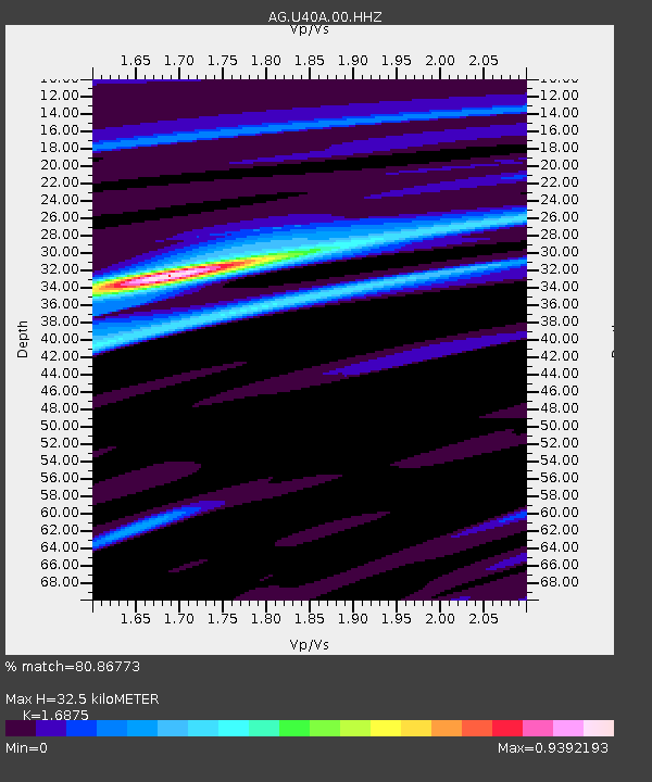
| Estimated Moho Depth: |
32.5 km |
| Estimated Crust Vp/Vs: |
1.69 |
| Assumed Crust Vp: |
6.53 km/s |
| Estimated Crust Vs: |
3.87 km/s |
| Estimated Crust Poisson's Ratio: |
0.23 |
|
| Radial Match: |
80.86773 % |
| Radial Bump: |
400 |
| Transverse Match: |
57.545334 % |
| Transverse Bump: |
400 |
| SOD ConfigId: |
11737051 |
| Insert Time: |
2019-04-24 23:33:16.874 +0000 |
| GWidth: |
2.5 |
| Max Bumps: |
400 |
| Tol: |
0.001 |
|
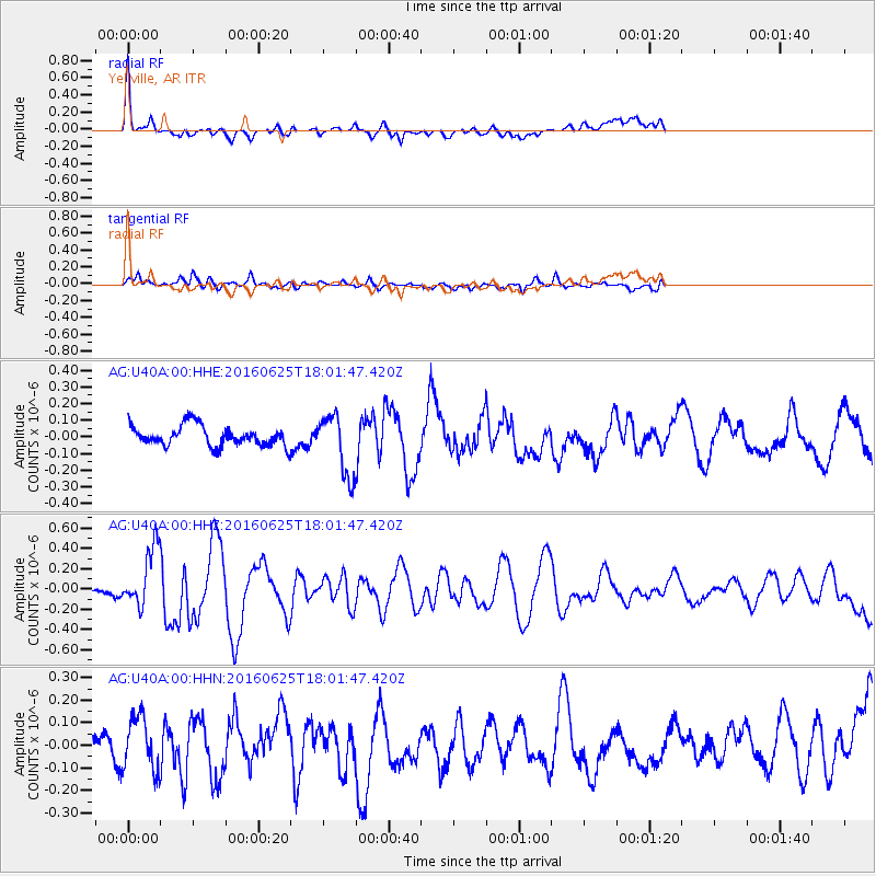
Signal To Noise
| Channel | StoN | STA | LTA |
| AG:U40A:00:HHZ:20160625T18:01:47.420Z | 3.675355 | 2.9151974E-7 | 7.931744E-8 |
| AG:U40A:00:HHN:20160625T18:01:47.420Z | 2.2511048 | 1.1706461E-7 | 5.200318E-8 |
| AG:U40A:00:HHE:20160625T18:01:47.420Z | 3.0111637 | 1.8261676E-7 | 6.064658E-8 |
| Arrivals |
| Ps | 3.7 SECOND |
| PpPs | 12 SECOND |
| PsPs/PpSs | 16 SECOND |


