You are here: Home > Network List > US - United States National Seismic Network Stations List
> Station WUAZ Wupatki, Arizona, USA > Earthquake Result Viewer
WUAZ Wupatki, Arizona, USA - Earthquake Result Viewer

| Earthquake location: |
Santa Cruz Islands |
| Earthquake latitude/longitude: |
-12.6/166.0 |
| Earthquake time(UTC): |
2009/10/07 (280) 23:23:28 GMT |
| Earthquake Depth: |
36 km |
| Earthquake Magnitude: |
5.5 MB |
| Earthquake Catalog/Contributor: |
WHDF/NEIC |
|
| Network: |
US United States National Seismic Network |
| Station: |
WUAZ Wupatki, Arizona, USA |
| Lat/Lon: |
35.52 N/111.37 W |
| Elevation: |
1592 m |
|
| Distance: |
91.3 deg |
| Az: |
54.031 deg |
| Baz: |
255.614 deg |
| Ray Param: |
0.041604616 |
| Estimated Moho Depth: |
56.5 km |
| Estimated Crust Vp/Vs: |
1.63 |
| Assumed Crust Vp: |
6.207 km/s |
| Estimated Crust Vs: |
3.808 km/s |
| Estimated Crust Poisson's Ratio: |
0.20 |
|
| Radial Match: |
94.56094 % |
| Radial Bump: |
374 |
| Transverse Match: |
74.99441 % |
| Transverse Bump: |
255 |
| SOD ConfigId: |
2622 |
| Insert Time: |
2010-03-05 04:53:40.330 +0000 |
| GWidth: |
2.5 |
| Max Bumps: |
400 |
| Tol: |
0.001 |
|
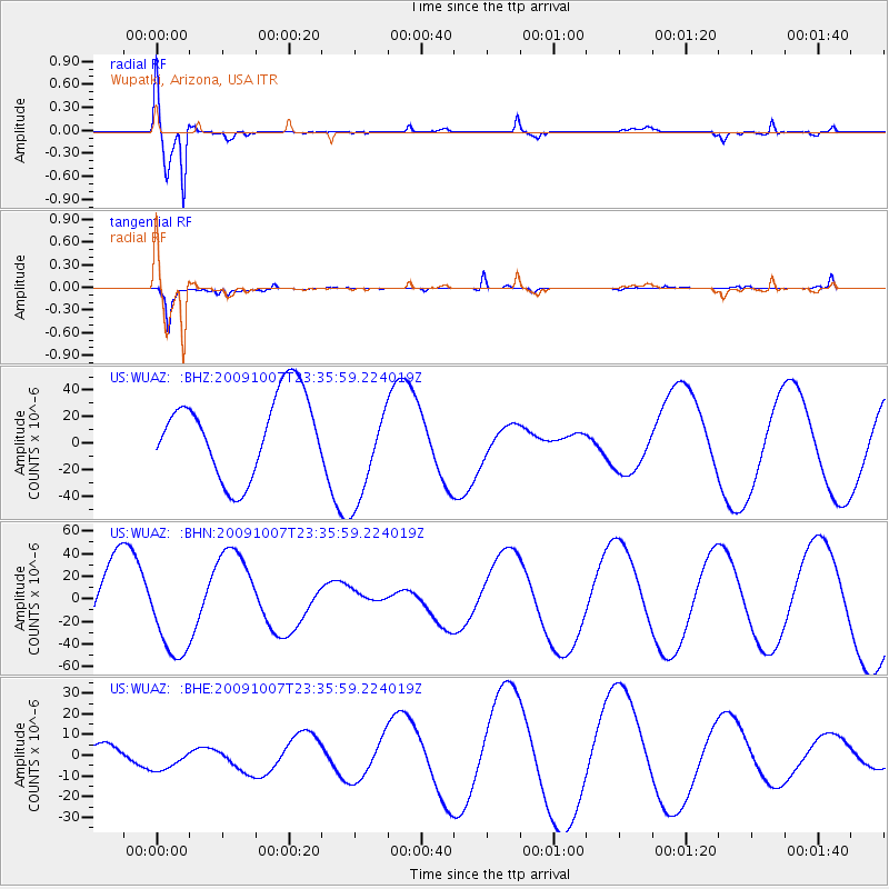
Signal To Noise
| Channel | StoN | STA | LTA |
| US:WUAZ: :BHN:20091007T23:35:59.224019Z | 1.4329259 | 4.0433508E-5 | 2.8217444E-5 |
| US:WUAZ: :BHE:20091007T23:35:59.224019Z | 0.6365287 | 5.740104E-6 | 9.017825E-6 |
| US:WUAZ: :BHZ:20091007T23:35:59.224019Z | 1.3348541 | 4.022268E-5 | 3.013264E-5 |
| Arrivals |
| Ps | 5.9 SECOND |
| PpPs | 23 SECOND |
| PsPs/PpSs | 29 SECOND |


