You are here: Home > Network List > N4 - Central and EAstern US Network Stations List
> Station P53A Whipple, OH, USA > Earthquake Result Viewer
P53A Whipple, OH, USA - Earthquake Result Viewer
| Earthquake location: |
Reykjanes Ridge |
| Earthquake latitude/longitude: |
53.9/-35.4 |
| Earthquake time(UTC): |
2016/06/25 (177) 17:54:19 GMT |
| Earthquake Depth: |
10 km |
| Earthquake Magnitude: |
5.5 MWC, 5.5 MWC |
| Earthquake Catalog/Contributor: |
NEIC PDE/NEIC COMCAT |
|
| Network: |
N4 Central and EAstern US Network |
| Station: |
P53A Whipple, OH, USA |
| Lat/Lon: |
39.49 N/81.39 W |
| Elevation: |
270 m |
|
| Distance: |
34.1 deg |
| Az: |
264.029 deg |
| Baz: |
49.518 deg |
| Ray Param: |
0.07792314 |
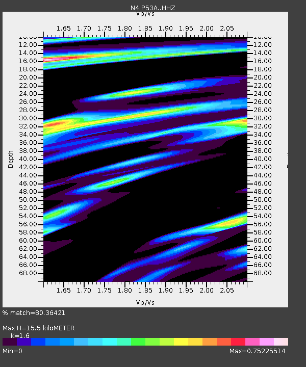
| Estimated Moho Depth: |
15.5 km |
| Estimated Crust Vp/Vs: |
1.60 |
| Assumed Crust Vp: |
6.207 km/s |
| Estimated Crust Vs: |
3.879 km/s |
| Estimated Crust Poisson's Ratio: |
0.18 |
|
| Radial Match: |
80.36421 % |
| Radial Bump: |
367 |
| Transverse Match: |
56.215443 % |
| Transverse Bump: |
373 |
| SOD ConfigId: |
11737051 |
| Insert Time: |
2019-04-24 23:37:43.484 +0000 |
| GWidth: |
2.5 |
| Max Bumps: |
400 |
| Tol: |
0.001 |
|

Signal To Noise
| Channel | StoN | STA | LTA |
| N4:P53A: :HHZ:20160625T18:00:33.199999Z | 2.7427928 | 2.710222E-7 | 9.881249E-8 |
| N4:P53A: :HHN:20160625T18:00:33.199999Z | 1.4166355 | 1.2295816E-7 | 8.679589E-8 |
| N4:P53A: :HHE:20160625T18:00:33.199999Z | 1.8284543 | 1.1591295E-7 | 6.3393955E-8 |
| Arrivals |
| Ps | 1.6 SECOND |
| PpPs | 6.0 SECOND |
| PsPs/PpSs | 7.6 SECOND |


