You are here: Home > Network List > TA - USArray Transportable Network (new EarthScope stations) Stations List
> Station H04D Lebanon, OR, USA > Earthquake Result Viewer
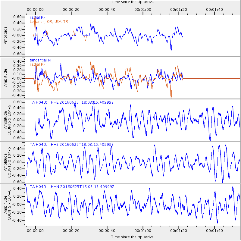
H04D Lebanon, OR, USA - Earthquake Result Viewer
*The percent match for this event was below the threshold and hence no stack was calculated.
| Earthquake location: |
Reykjanes Ridge |
| Earthquake latitude/longitude: |
53.9/-35.4 |
| Earthquake time(UTC): |
2016/06/25 (177) 17:54:19 GMT |
| Earthquake Depth: |
10 km |
| Earthquake Magnitude: |
5.5 MWC, 5.5 MWC |
| Earthquake Catalog/Contributor: |
NEIC PDE/NEIC COMCAT |
|
| Network: |
TA USArray Transportable Network (new EarthScope stations) |
| Station: |
H04D Lebanon, OR, USA |
| Lat/Lon: |
44.52 N/122.74 W |
| Elevation: |
284 m |
|
| Distance: |
54.4 deg |
| Az: |
298.451 deg |
| Baz: |
46.671 deg |
| Ray Param: |
$rayparam |
*The percent match for this event was below the threshold and hence was not used in the summary stack. |
|
| Radial Match: |
53.391376 % |
| Radial Bump: |
400 |
| Transverse Match: |
63.30288 % |
| Transverse Bump: |
400 |
| SOD ConfigId: |
11737051 |
| Insert Time: |
2019-04-24 23:39:47.256 +0000 |
| GWidth: |
2.5 |
| Max Bumps: |
400 |
| Tol: |
0.001 |
|
Signal To Noise
| Channel | StoN | STA | LTA |
| TA:H04D: :HHZ:20160625T18:03:15.40999Z | 0.9690687 | 2.2658686E-7 | 2.3381921E-7 |
| TA:H04D: :HHN:20160625T18:03:15.40999Z | 0.90688735 | 2.5718387E-7 | 2.8358963E-7 |
| TA:H04D: :HHE:20160625T18:03:15.40999Z | 1.0972282 | 2.9967808E-7 | 2.7312285E-7 |
| Arrivals |
| Ps | |
| PpPs | |
| PsPs/PpSs | |


