You are here: Home > Network List > AK - Alaska Regional Network Stations List
> Station PPLA Purkeypile > Earthquake Result Viewer
PPLA Purkeypile - Earthquake Result Viewer
| Earthquake location: |
Tajikistan-Xinjiang Border Reg. |
| Earthquake latitude/longitude: |
39.5/73.3 |
| Earthquake time(UTC): |
2016/06/26 (178) 11:17:11 GMT |
| Earthquake Depth: |
16 km |
| Earthquake Magnitude: |
6.4 MWW, 6.3 MWB |
| Earthquake Catalog/Contributor: |
NEIC PDE/NEIC COMCAT |
|
| Network: |
AK Alaska Regional Network |
| Station: |
PPLA Purkeypile |
| Lat/Lon: |
62.90 N/152.19 W |
| Elevation: |
1519 m |
|
| Distance: |
71.7 deg |
| Az: |
20.135 deg |
| Baz: |
324.436 deg |
| Ray Param: |
0.054167993 |
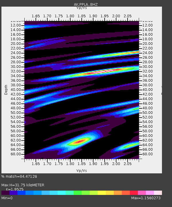
| Estimated Moho Depth: |
31.75 km |
| Estimated Crust Vp/Vs: |
1.95 |
| Assumed Crust Vp: |
6.566 km/s |
| Estimated Crust Vs: |
3.363 km/s |
| Estimated Crust Poisson's Ratio: |
0.32 |
|
| Radial Match: |
84.47126 % |
| Radial Bump: |
392 |
| Transverse Match: |
79.367905 % |
| Transverse Bump: |
400 |
| SOD ConfigId: |
11737051 |
| Insert Time: |
2019-04-24 23:42:58.377 +0000 |
| GWidth: |
2.5 |
| Max Bumps: |
400 |
| Tol: |
0.001 |
|

Signal To Noise
| Channel | StoN | STA | LTA |
| AK:PPLA: :BHZ:20160626T11:28:01.328Z | 4.052488 | 3.3070344E-7 | 8.160505E-8 |
| AK:PPLA: :BHN:20160626T11:28:01.328Z | 1.2381629 | 1.3046063E-7 | 1.053663E-7 |
| AK:PPLA: :BHE:20160626T11:28:01.328Z | 1.5109377 | 1.3230292E-7 | 8.756346E-8 |
| Arrivals |
| Ps | 4.8 SECOND |
| PpPs | 14 SECOND |
| PsPs/PpSs | 19 SECOND |


