You are here: Home > Network List > AK - Alaska Regional Network Stations List
> Station WAT7 Susitna Watana 7, AK, USA > Earthquake Result Viewer
WAT7 Susitna Watana 7, AK, USA - Earthquake Result Viewer
| Earthquake location: |
Tajikistan-Xinjiang Border Reg. |
| Earthquake latitude/longitude: |
39.5/73.3 |
| Earthquake time(UTC): |
2016/06/26 (178) 11:17:11 GMT |
| Earthquake Depth: |
16 km |
| Earthquake Magnitude: |
6.4 MWW, 6.3 MWB |
| Earthquake Catalog/Contributor: |
NEIC PDE/NEIC COMCAT |
|
| Network: |
AK Alaska Regional Network |
| Station: |
WAT7 Susitna Watana 7, AK, USA |
| Lat/Lon: |
62.83 N/148.85 W |
| Elevation: |
1232 m |
|
| Distance: |
72.6 deg |
| Az: |
18.844 deg |
| Baz: |
327.007 deg |
| Ray Param: |
0.053558562 |
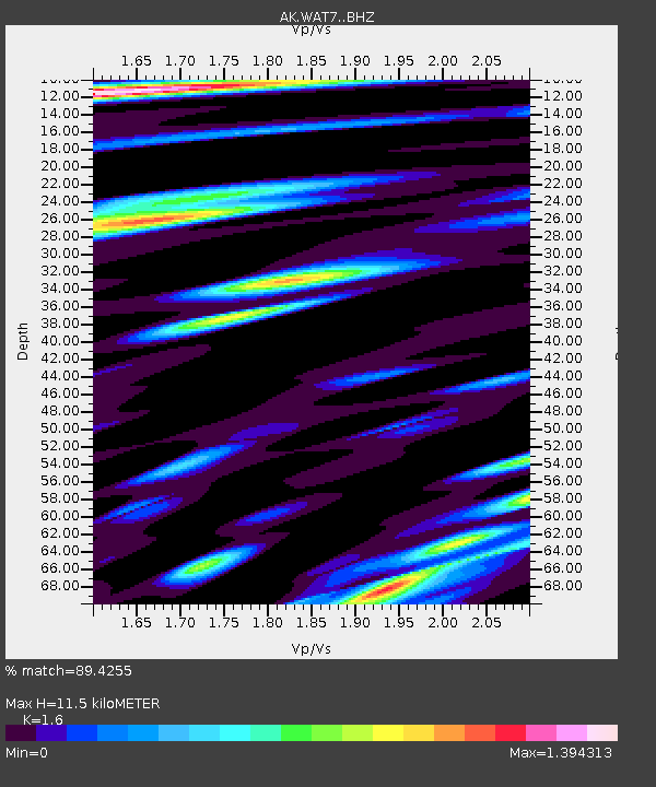
| Estimated Moho Depth: |
11.5 km |
| Estimated Crust Vp/Vs: |
1.60 |
| Assumed Crust Vp: |
6.566 km/s |
| Estimated Crust Vs: |
4.104 km/s |
| Estimated Crust Poisson's Ratio: |
0.18 |
|
| Radial Match: |
89.4255 % |
| Radial Bump: |
400 |
| Transverse Match: |
82.590004 % |
| Transverse Bump: |
400 |
| SOD ConfigId: |
11737051 |
| Insert Time: |
2019-04-24 23:43:12.415 +0000 |
| GWidth: |
2.5 |
| Max Bumps: |
400 |
| Tol: |
0.001 |
|

Signal To Noise
| Channel | StoN | STA | LTA |
| AK:WAT7: :BHZ:20160626T11:28:06.788022Z | 3.0523484 | 3.0832865E-7 | 1.0101358E-7 |
| AK:WAT7: :BHN:20160626T11:28:06.788022Z | 1.7925409 | 1.4446833E-7 | 8.0594155E-8 |
| AK:WAT7: :BHE:20160626T11:28:06.788022Z | 1.5476339 | 1.4179844E-7 | 9.162273E-8 |
| Arrivals |
| Ps | 1.1 SECOND |
| PpPs | 4.4 SECOND |
| PsPs/PpSs | 5.5 SECOND |


