You are here: Home > Network List > AV - Alaska Volcano Observatory Stations List
> Station AMKA Regional Station, Amchitka Island, Alaska > Earthquake Result Viewer
AMKA Regional Station, Amchitka Island, Alaska - Earthquake Result Viewer
| Earthquake location: |
Tajikistan-Xinjiang Border Reg. |
| Earthquake latitude/longitude: |
39.5/73.3 |
| Earthquake time(UTC): |
2016/06/26 (178) 11:17:11 GMT |
| Earthquake Depth: |
16 km |
| Earthquake Magnitude: |
6.4 MWW, 6.3 MWB |
| Earthquake Catalog/Contributor: |
NEIC PDE/NEIC COMCAT |
|
| Network: |
AV Alaska Volcano Observatory |
| Station: |
AMKA Regional Station, Amchitka Island, Alaska |
| Lat/Lon: |
51.38 N/179.30 E |
| Elevation: |
116 m |
|
| Distance: |
68.9 deg |
| Az: |
40.228 deg |
| Baz: |
307.113 deg |
| Ray Param: |
0.05599192 |
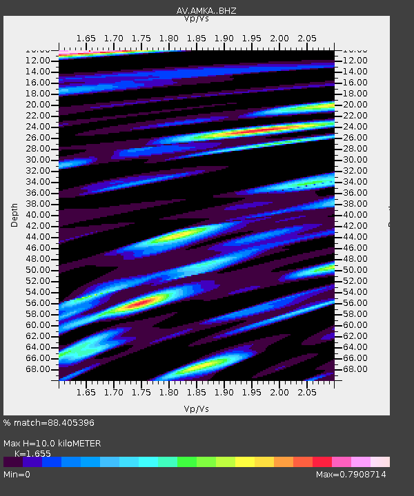
| Estimated Moho Depth: |
10.0 km |
| Estimated Crust Vp/Vs: |
1.65 |
| Assumed Crust Vp: |
6.183 km/s |
| Estimated Crust Vs: |
3.736 km/s |
| Estimated Crust Poisson's Ratio: |
0.21 |
|
| Radial Match: |
88.405396 % |
| Radial Bump: |
400 |
| Transverse Match: |
86.56067 % |
| Transverse Bump: |
400 |
| SOD ConfigId: |
11737051 |
| Insert Time: |
2019-04-24 23:43:27.810 +0000 |
| GWidth: |
2.5 |
| Max Bumps: |
400 |
| Tol: |
0.001 |
|
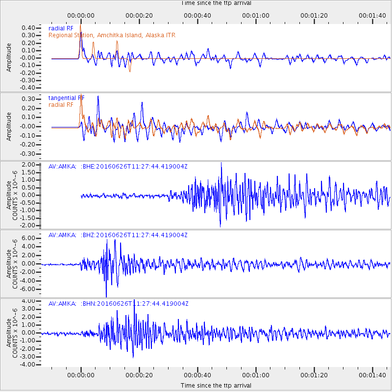
Signal To Noise
| Channel | StoN | STA | LTA |
| AV:AMKA: :BHZ:20160626T11:27:44.419004Z | 10.300417 | 7.3878203E-7 | 7.1723505E-8 |
| AV:AMKA: :BHN:20160626T11:27:44.419004Z | 2.4210236 | 1.851534E-7 | 7.647732E-8 |
| AV:AMKA: :BHE:20160626T11:27:44.419004Z | 2.3926928 | 1.6150291E-7 | 6.749839E-8 |
| Arrivals |
| Ps | 1.1 SECOND |
| PpPs | 4.1 SECOND |
| PsPs/PpSs | 5.2 SECOND |


