You are here: Home > Network List > US - United States National Seismic Network Stations List
> Station WUAZ Wupatki, Arizona, USA > Earthquake Result Viewer
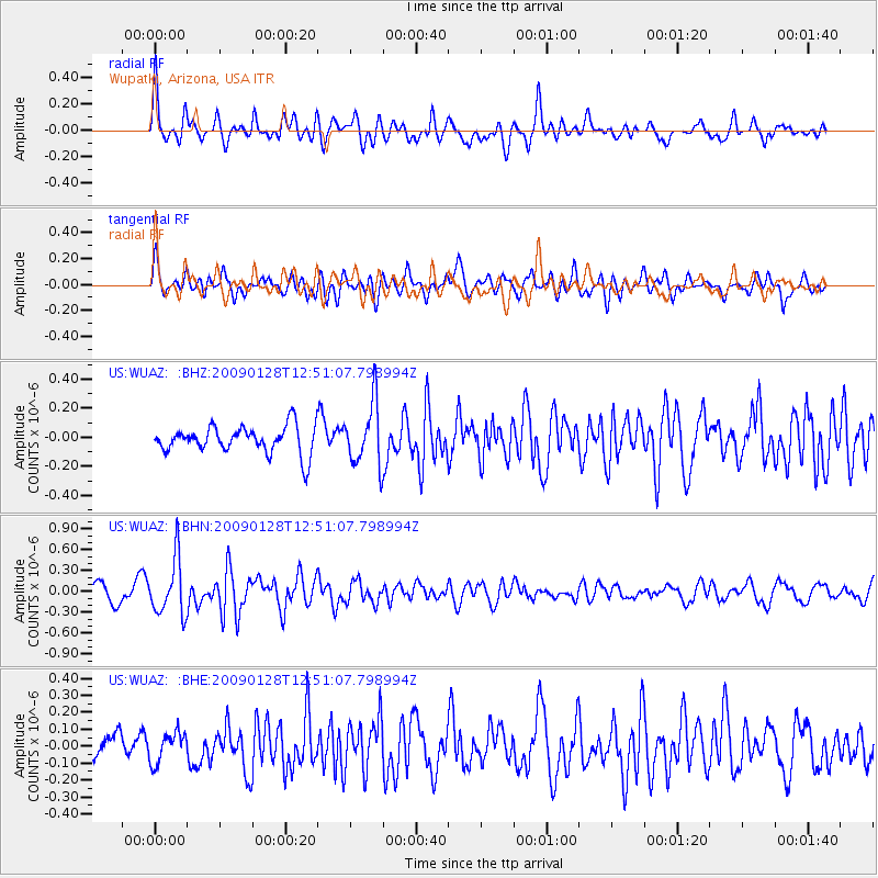
WUAZ Wupatki, Arizona, USA - Earthquake Result Viewer
*The percent match for this event was below the threshold and hence no stack was calculated.
| Earthquake location: |
Samoa Islands Region |
| Earthquake latitude/longitude: |
-17.0/-172.1 |
| Earthquake time(UTC): |
2009/01/28 (028) 12:39:42 GMT |
| Earthquake Depth: |
10 km |
| Earthquake Magnitude: |
5.6 MB, 5.3 MS, 5.5 MW |
| Earthquake Catalog/Contributor: |
WHDF/NEIC |
|
| Network: |
US United States National Seismic Network |
| Station: |
WUAZ Wupatki, Arizona, USA |
| Lat/Lon: |
35.52 N/111.37 W |
| Elevation: |
1592 m |
|
| Distance: |
77.6 deg |
| Az: |
46.744 deg |
| Baz: |
238.69 deg |
| Ray Param: |
$rayparam |
*The percent match for this event was below the threshold and hence was not used in the summary stack. |
|
| Radial Match: |
69.935905 % |
| Radial Bump: |
400 |
| Transverse Match: |
68.18892 % |
| Transverse Bump: |
400 |
| SOD ConfigId: |
2658 |
| Insert Time: |
2010-03-05 04:55:11.160 +0000 |
| GWidth: |
2.5 |
| Max Bumps: |
400 |
| Tol: |
0.001 |
|
Signal To Noise
| Channel | StoN | STA | LTA |
| US:WUAZ: :BHN:20090128T12:51:07.798994Z | 3.553097 | 4.0354522E-7 | 1.1357563E-7 |
| US:WUAZ: :BHE:20090128T12:51:07.798994Z | 0.83123386 | 8.8446E-8 | 1.0640326E-7 |
| US:WUAZ: :BHZ:20090128T12:51:07.798994Z | 2.282728 | 2.1382223E-7 | 9.3669605E-8 |
| Arrivals |
| Ps | |
| PpPs | |
| PsPs/PpSs | |


