You are here: Home > Network List > TA - USArray Transportable Network (new EarthScope stations) Stations List
> Station C27K Jago River, AK, USA > Earthquake Result Viewer
C27K Jago River, AK, USA - Earthquake Result Viewer
| Earthquake location: |
Tajikistan-Xinjiang Border Reg. |
| Earthquake latitude/longitude: |
39.5/73.3 |
| Earthquake time(UTC): |
2016/06/26 (178) 11:17:11 GMT |
| Earthquake Depth: |
16 km |
| Earthquake Magnitude: |
6.4 MWW, 6.3 MWB |
| Earthquake Catalog/Contributor: |
NEIC PDE/NEIC COMCAT |
|
| Network: |
TA USArray Transportable Network (new EarthScope stations) |
| Station: |
C27K Jago River, AK, USA |
| Lat/Lon: |
69.63 N/143.71 W |
| Elevation: |
392 m |
|
| Distance: |
67.9 deg |
| Az: |
13.164 deg |
| Baz: |
329.786 deg |
| Ray Param: |
0.056671634 |
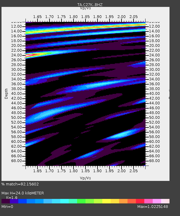
| Estimated Moho Depth: |
24.0 km |
| Estimated Crust Vp/Vs: |
1.60 |
| Assumed Crust Vp: |
6.522 km/s |
| Estimated Crust Vs: |
4.076 km/s |
| Estimated Crust Poisson's Ratio: |
0.18 |
|
| Radial Match: |
92.15602 % |
| Radial Bump: |
400 |
| Transverse Match: |
87.84883 % |
| Transverse Bump: |
400 |
| SOD ConfigId: |
11737051 |
| Insert Time: |
2019-04-24 23:46:36.257 +0000 |
| GWidth: |
2.5 |
| Max Bumps: |
400 |
| Tol: |
0.001 |
|

Signal To Noise
| Channel | StoN | STA | LTA |
| TA:C27K: :BHZ:20160626T11:27:37.974973Z | 4.1108713 | 2.4948076E-7 | 6.068805E-8 |
| TA:C27K: :BHN:20160626T11:27:37.974973Z | 1.6926957 | 8.340097E-8 | 4.9271094E-8 |
| TA:C27K: :BHE:20160626T11:27:37.974973Z | 0.8982842 | 4.1200646E-8 | 4.5865935E-8 |
| Arrivals |
| Ps | 2.3 SECOND |
| PpPs | 9.1 SECOND |
| PsPs/PpSs | 11 SECOND |


