You are here: Home > Network List > TA - USArray Transportable Network (new EarthScope stations) Stations List
> Station H23K Yukon River, AK, USA > Earthquake Result Viewer
H23K Yukon River, AK, USA - Earthquake Result Viewer
| Earthquake location: |
Tajikistan-Xinjiang Border Reg. |
| Earthquake latitude/longitude: |
39.5/73.3 |
| Earthquake time(UTC): |
2016/06/26 (178) 11:17:11 GMT |
| Earthquake Depth: |
16 km |
| Earthquake Magnitude: |
6.4 MWW, 6.3 MWB |
| Earthquake Catalog/Contributor: |
NEIC PDE/NEIC COMCAT |
|
| Network: |
TA USArray Transportable Network (new EarthScope stations) |
| Station: |
H23K Yukon River, AK, USA |
| Lat/Lon: |
65.83 N/149.54 W |
| Elevation: |
617 m |
|
| Distance: |
69.9 deg |
| Az: |
17.357 deg |
| Baz: |
325.903 deg |
| Ray Param: |
0.055325374 |
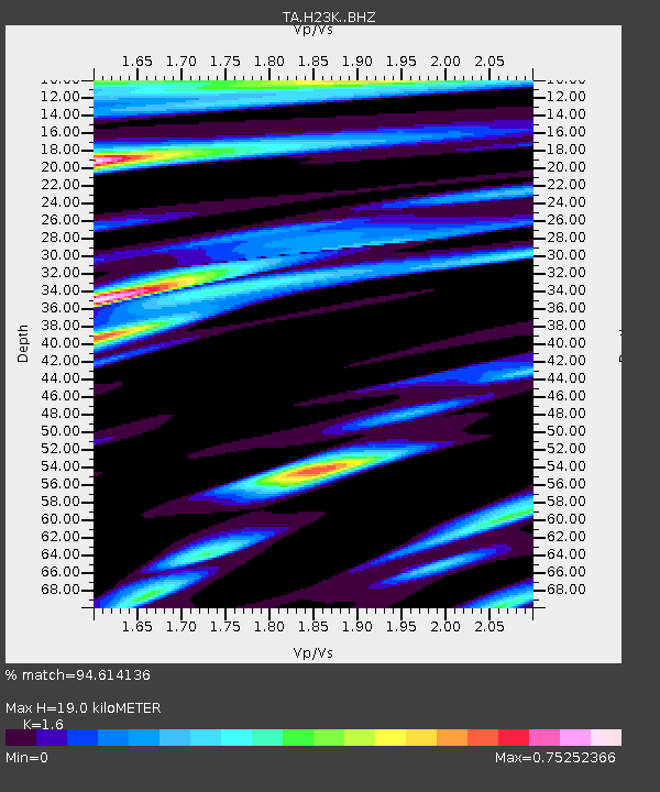
| Estimated Moho Depth: |
19.0 km |
| Estimated Crust Vp/Vs: |
1.60 |
| Assumed Crust Vp: |
6.566 km/s |
| Estimated Crust Vs: |
4.104 km/s |
| Estimated Crust Poisson's Ratio: |
0.18 |
|
| Radial Match: |
94.614136 % |
| Radial Bump: |
400 |
| Transverse Match: |
87.405045 % |
| Transverse Bump: |
400 |
| SOD ConfigId: |
11737051 |
| Insert Time: |
2019-04-24 23:46:48.161 +0000 |
| GWidth: |
2.5 |
| Max Bumps: |
400 |
| Tol: |
0.001 |
|

Signal To Noise
| Channel | StoN | STA | LTA |
| TA:H23K: :BHZ:20160626T11:27:50.674985Z | 4.8117356 | 1.8809077E-7 | 3.9090004E-8 |
| TA:H23K: :BHN:20160626T11:27:50.674985Z | 1.7778842 | 7.937052E-8 | 4.4643244E-8 |
| TA:H23K: :BHE:20160626T11:27:50.674985Z | 1.6030804 | 8.788797E-8 | 5.482443E-8 |
| Arrivals |
| Ps | 1.8 SECOND |
| PpPs | 7.2 SECOND |
| PsPs/PpSs | 9.0 SECOND |


