You are here: Home > Network List > TA - USArray Transportable Network (new EarthScope stations) Stations List
> Station I21K Tanana, AK, USA > Earthquake Result Viewer
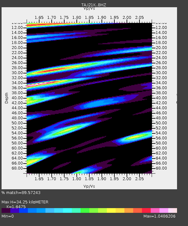
I21K Tanana, AK, USA - Earthquake Result Viewer
| Earthquake location: |
Tajikistan-Xinjiang Border Reg. |
| Earthquake latitude/longitude: |
39.5/73.3 |
| Earthquake time(UTC): |
2016/06/26 (178) 11:17:11 GMT |
| Earthquake Depth: |
16 km |
| Earthquake Magnitude: |
6.4 MWW, 6.3 MWB |
| Earthquake Catalog/Contributor: |
NEIC PDE/NEIC COMCAT |
|
| Network: |
TA USArray Transportable Network (new EarthScope stations) |
| Station: |
I21K Tanana, AK, USA |
| Lat/Lon: |
65.18 N/151.98 W |
| Elevation: |
248 m |
|
| Distance: |
69.9 deg |
| Az: |
18.64 deg |
| Baz: |
324.127 deg |
| Ray Param: |
0.055360056 |
| Estimated Moho Depth: |
34.25 km |
| Estimated Crust Vp/Vs: |
1.65 |
| Assumed Crust Vp: |
6.566 km/s |
| Estimated Crust Vs: |
3.986 km/s |
| Estimated Crust Poisson's Ratio: |
0.21 |
|
| Radial Match: |
89.57243 % |
| Radial Bump: |
400 |
| Transverse Match: |
81.48346 % |
| Transverse Bump: |
400 |
| SOD ConfigId: |
11737051 |
| Insert Time: |
2019-04-24 23:46:51.587 +0000 |
| GWidth: |
2.5 |
| Max Bumps: |
400 |
| Tol: |
0.001 |
|

Signal To Noise
| Channel | StoN | STA | LTA |
| TA:I21K: :BHZ:20160626T11:27:50.349973Z | 2.9579566 | 2.3515035E-7 | 7.949757E-8 |
| TA:I21K: :BHN:20160626T11:27:50.349973Z | 1.4068288 | 1.0996804E-7 | 7.8167325E-8 |
| TA:I21K: :BHE:20160626T11:27:50.349973Z | 1.5522505 | 9.421864E-8 | 6.069809E-8 |
| Arrivals |
| Ps | 3.5 SECOND |
| PpPs | 13 SECOND |
| PsPs/PpSs | 17 SECOND |


