You are here: Home > Network List > TA - USArray Transportable Network (new EarthScope stations) Stations List
> Station N16K Nishlik Lake, AK, USA > Earthquake Result Viewer
N16K Nishlik Lake, AK, USA - Earthquake Result Viewer
| Earthquake location: |
Tajikistan-Xinjiang Border Reg. |
| Earthquake latitude/longitude: |
39.5/73.3 |
| Earthquake time(UTC): |
2016/06/26 (178) 11:17:11 GMT |
| Earthquake Depth: |
16 km |
| Earthquake Magnitude: |
6.4 MWW, 6.3 MWB |
| Earthquake Catalog/Contributor: |
NEIC PDE/NEIC COMCAT |
|
| Network: |
TA USArray Transportable Network (new EarthScope stations) |
| Station: |
N16K Nishlik Lake, AK, USA |
| Lat/Lon: |
60.47 N/158.77 W |
| Elevation: |
582 m |
|
| Distance: |
71.7 deg |
| Az: |
24.314 deg |
| Baz: |
319.963 deg |
| Ray Param: |
0.05417094 |
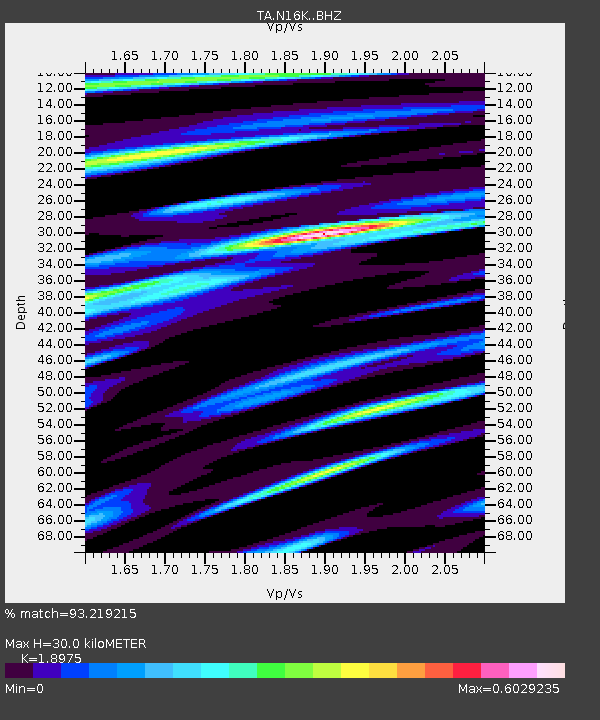
| Estimated Moho Depth: |
30.0 km |
| Estimated Crust Vp/Vs: |
1.90 |
| Assumed Crust Vp: |
6.276 km/s |
| Estimated Crust Vs: |
3.307 km/s |
| Estimated Crust Poisson's Ratio: |
0.31 |
|
| Radial Match: |
93.219215 % |
| Radial Bump: |
400 |
| Transverse Match: |
90.860794 % |
| Transverse Bump: |
400 |
| SOD ConfigId: |
11737051 |
| Insert Time: |
2019-04-24 23:47:06.776 +0000 |
| GWidth: |
2.5 |
| Max Bumps: |
400 |
| Tol: |
0.001 |
|

Signal To Noise
| Channel | StoN | STA | LTA |
| TA:N16K: :BHZ:20160626T11:28:01.299985Z | 3.5155904 | 2.683713E-7 | 7.633748E-8 |
| TA:N16K: :BHN:20160626T11:28:01.299985Z | 1.3908643 | 1.0113319E-7 | 7.271248E-8 |
| TA:N16K: :BHE:20160626T11:28:01.299985Z | 1.7681277 | 1.3952564E-7 | 7.8911526E-8 |
| Arrivals |
| Ps | 4.4 SECOND |
| PpPs | 13 SECOND |
| PsPs/PpSs | 18 SECOND |


