You are here: Home > Network List > TA - USArray Transportable Network (new EarthScope stations) Stations List
> Station N25K Chitina, Valdez-Cordova, AK, USA > Earthquake Result Viewer
N25K Chitina, Valdez-Cordova, AK, USA - Earthquake Result Viewer
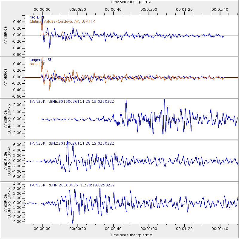
| Earthquake location: |
Tajikistan-Xinjiang Border Reg. |
| Earthquake latitude/longitude: |
39.5/73.3 |
| Earthquake time(UTC): |
2016/06/26 (178) 11:17:11 GMT |
| Earthquake Depth: |
16 km |
| Earthquake Magnitude: |
6.4 MWW, 6.3 MWB |
| Earthquake Catalog/Contributor: |
NEIC PDE/NEIC COMCAT |
|
| Network: |
TA USArray Transportable Network (new EarthScope stations) |
| Station: |
N25K Chitina, Valdez-Cordova, AK, USA |
| Lat/Lon: |
61.61 N/144.60 W |
| Elevation: |
1087 m |
|
| Distance: |
74.7 deg |
| Az: |
17.736 deg |
| Baz: |
330.45 deg |
| Ray Param: |
0.052172303 |
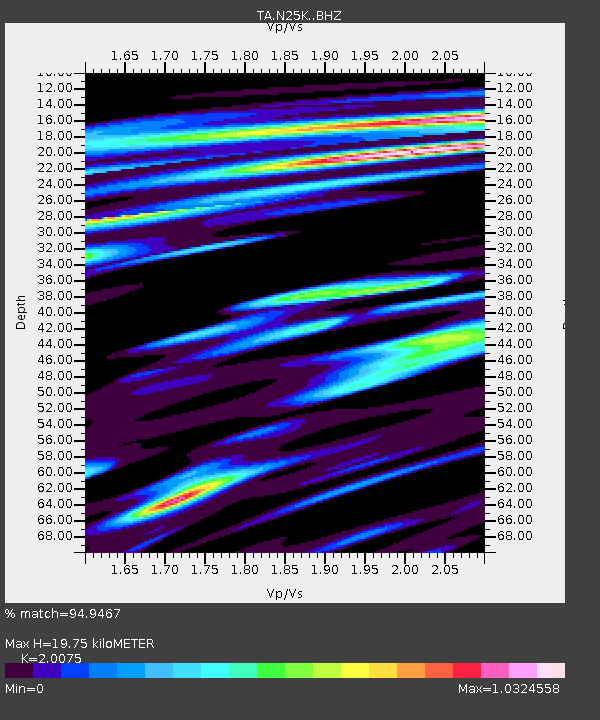
| Estimated Moho Depth: |
19.75 km |
| Estimated Crust Vp/Vs: |
2.01 |
| Assumed Crust Vp: |
6.566 km/s |
| Estimated Crust Vs: |
3.271 km/s |
| Estimated Crust Poisson's Ratio: |
0.33 |
|
| Radial Match: |
94.9467 % |
| Radial Bump: |
400 |
| Transverse Match: |
91.53706 % |
| Transverse Bump: |
400 |
| SOD ConfigId: |
11737051 |
| Insert Time: |
2019-04-24 23:47:07.862 +0000 |
| GWidth: |
2.5 |
| Max Bumps: |
400 |
| Tol: |
0.001 |
|
Signal To Noise
| Channel | StoN | STA | LTA |
| TA:N25K: :BHZ:20160626T11:28:19.025022Z | 2.3135622 | 2.8264947E-7 | 1.2217068E-7 |
| TA:N25K: :BHN:20160626T11:28:19.025022Z | 1.3686899 | 1.7085613E-7 | 1.2483187E-7 |
| TA:N25K: :BHE:20160626T11:28:19.025022Z | 2.2278607 | 1.5951987E-7 | 7.1602265E-8 |
| Arrivals |
| Ps | 3.1 SECOND |
| PpPs | 8.8 SECOND |
| PsPs/PpSs | 12 SECOND |


