You are here: Home > Network List > TA - USArray Transportable Network (new EarthScope stations) Stations List
> Station P33M Teslin, Yukon, CA > Earthquake Result Viewer
P33M Teslin, Yukon, CA - Earthquake Result Viewer
| Earthquake location: |
Tajikistan-Xinjiang Border Reg. |
| Earthquake latitude/longitude: |
39.5/73.3 |
| Earthquake time(UTC): |
2016/06/26 (178) 11:17:11 GMT |
| Earthquake Depth: |
16 km |
| Earthquake Magnitude: |
6.4 MWW, 6.3 MWB |
| Earthquake Catalog/Contributor: |
NEIC PDE/NEIC COMCAT |
|
| Network: |
TA USArray Transportable Network (new EarthScope stations) |
| Station: |
P33M Teslin, Yukon, CA |
| Lat/Lon: |
60.21 N/132.82 W |
| Elevation: |
1066 m |
|
| Distance: |
78.4 deg |
| Az: |
12.981 deg |
| Baz: |
339.627 deg |
| Ray Param: |
0.049689 |
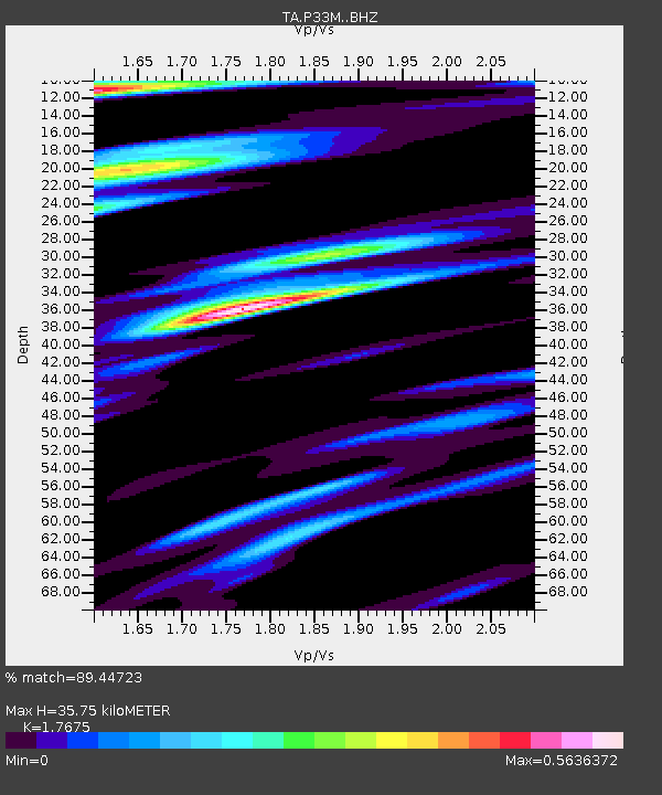
| Estimated Moho Depth: |
35.75 km |
| Estimated Crust Vp/Vs: |
1.77 |
| Assumed Crust Vp: |
6.419 km/s |
| Estimated Crust Vs: |
3.632 km/s |
| Estimated Crust Poisson's Ratio: |
0.26 |
|
| Radial Match: |
89.44723 % |
| Radial Bump: |
400 |
| Transverse Match: |
74.86354 % |
| Transverse Bump: |
400 |
| SOD ConfigId: |
11737051 |
| Insert Time: |
2019-04-24 23:47:15.168 +0000 |
| GWidth: |
2.5 |
| Max Bumps: |
400 |
| Tol: |
0.001 |
|

Signal To Noise
| Channel | StoN | STA | LTA |
| TA:P33M: :BHZ:20160626T11:28:39.874021Z | 2.319597 | 2.7051442E-7 | 1.166213E-7 |
| TA:P33M: :BHN:20160626T11:28:39.874021Z | 1.1206287 | 1.2422298E-7 | 1.1085114E-7 |
| TA:P33M: :BHE:20160626T11:28:39.874021Z | 0.96822876 | 1.4870976E-7 | 1.535895E-7 |
| Arrivals |
| Ps | 4.4 SECOND |
| PpPs | 15 SECOND |
| PsPs/PpSs | 19 SECOND |


