You are here: Home > Network List > IW - Intermountain West Stations List
> Station MOOW Moose Ponds, Wyoming, USA > Earthquake Result Viewer
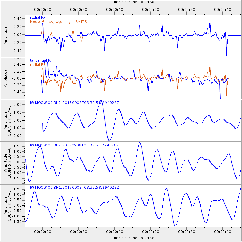
MOOW Moose Ponds, Wyoming, USA - Earthquake Result Viewer
*The percent match for this event was below the threshold and hence no stack was calculated.
| Earthquake location: |
South Of Kermadec Islands |
| Earthquake latitude/longitude: |
-33.1/-178.2 |
| Earthquake time(UTC): |
2015/09/08 (251) 08:19:53 GMT |
| Earthquake Depth: |
11 km |
| Earthquake Magnitude: |
5.5 MB |
| Earthquake Catalog/Contributor: |
NEIC PDE/NEIC COMCAT |
|
| Network: |
IW Intermountain West |
| Station: |
MOOW Moose Ponds, Wyoming, USA |
| Lat/Lon: |
43.75 N/110.74 W |
| Elevation: |
2128 m |
|
| Distance: |
98.2 deg |
| Az: |
42.551 deg |
| Baz: |
231.532 deg |
| Ray Param: |
$rayparam |
*The percent match for this event was below the threshold and hence was not used in the summary stack. |
|
| Radial Match: |
61.10878 % |
| Radial Bump: |
400 |
| Transverse Match: |
63.702812 % |
| Transverse Bump: |
400 |
| SOD ConfigId: |
1156111 |
| Insert Time: |
2015-09-22 08:29:37.154 +0000 |
| GWidth: |
2.5 |
| Max Bumps: |
400 |
| Tol: |
0.001 |
|
Signal To Noise
| Channel | StoN | STA | LTA |
| IW:MOOW:00:BHZ:20150908T08:32:58.294028Z | 0.6842633 | 7.451847E-7 | 1.0890321E-6 |
| IW:MOOW:00:BH1:20150908T08:32:58.294028Z | 0.4717639 | 3.4136997E-7 | 7.2360336E-7 |
| IW:MOOW:00:BH2:20150908T08:32:58.294028Z | 2.3944588 | 1.7485813E-6 | 7.3026155E-7 |
| Arrivals |
| Ps | |
| PpPs | |
| PsPs/PpSs | |


