You are here: Home > Network List > IW - Intermountain West Stations List
> Station MOOW Moose Ponds, Wyoming, USA > Earthquake Result Viewer
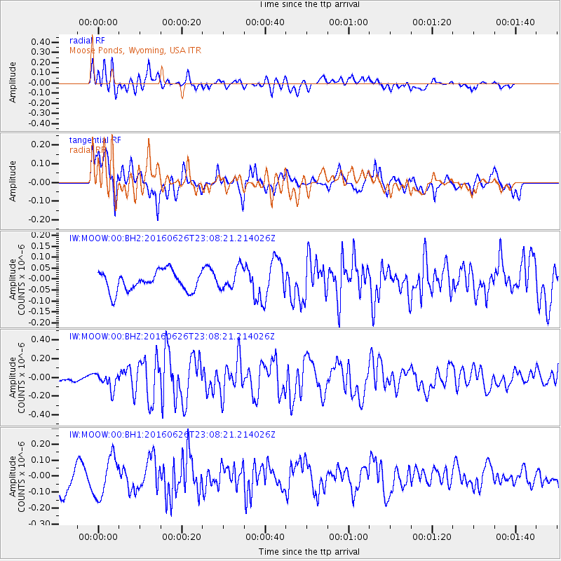
MOOW Moose Ponds, Wyoming, USA - Earthquake Result Viewer
*The percent match for this event was below the threshold and hence no stack was calculated.
| Earthquake location: |
Off East Coast Of Honshu, Japan |
| Earthquake latitude/longitude: |
37.0/142.1 |
| Earthquake time(UTC): |
2016/06/26 (178) 22:57:08 GMT |
| Earthquake Depth: |
19 km |
| Earthquake Magnitude: |
5.5 MWR |
| Earthquake Catalog/Contributor: |
NEIC PDE/NEIC COMCAT |
|
| Network: |
IW Intermountain West |
| Station: |
MOOW Moose Ponds, Wyoming, USA |
| Lat/Lon: |
43.75 N/110.74 W |
| Elevation: |
2128 m |
|
| Distance: |
75.9 deg |
| Az: |
45.561 deg |
| Baz: |
307.976 deg |
| Ray Param: |
$rayparam |
*The percent match for this event was below the threshold and hence was not used in the summary stack. |
|
| Radial Match: |
67.55267 % |
| Radial Bump: |
400 |
| Transverse Match: |
60.762104 % |
| Transverse Bump: |
400 |
| SOD ConfigId: |
11737051 |
| Insert Time: |
2019-04-24 23:52:42.688 +0000 |
| GWidth: |
2.5 |
| Max Bumps: |
400 |
| Tol: |
0.001 |
|
Signal To Noise
| Channel | StoN | STA | LTA |
| IW:MOOW:00:BHZ:20160626T23:08:21.214026Z | 1.243092 | 8.5846565E-8 | 6.90589E-8 |
| IW:MOOW:00:BH1:20160626T23:08:21.214026Z | 1.9189794 | 1.2532755E-7 | 6.530948E-8 |
| IW:MOOW:00:BH2:20160626T23:08:21.214026Z | 1.2085221 | 5.6039735E-8 | 4.637047E-8 |
| Arrivals |
| Ps | |
| PpPs | |
| PsPs/PpSs | |


