You are here: Home > Network List > US - United States National Seismic Network Stations List
> Station WUAZ Wupatki, Arizona, USA > Earthquake Result Viewer
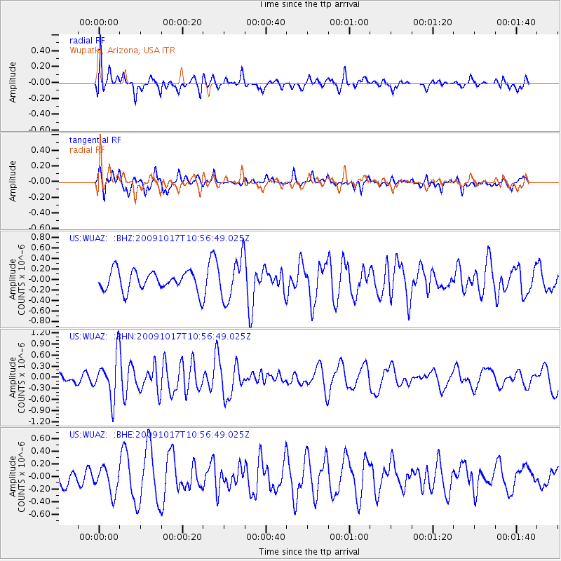
WUAZ Wupatki, Arizona, USA - Earthquake Result Viewer
*The percent match for this event was below the threshold and hence no stack was calculated.
| Earthquake location: |
Samoa Islands Region |
| Earthquake latitude/longitude: |
-16.4/-172.0 |
| Earthquake time(UTC): |
2009/10/17 (290) 10:45:26 GMT |
| Earthquake Depth: |
10 km |
| Earthquake Magnitude: |
5.7 MB, 5.3 MS, 5.7 MW, 5.7 MW |
| Earthquake Catalog/Contributor: |
WHDF/NEIC |
|
| Network: |
US United States National Seismic Network |
| Station: |
WUAZ Wupatki, Arizona, USA |
| Lat/Lon: |
35.52 N/111.37 W |
| Elevation: |
1592 m |
|
| Distance: |
77.2 deg |
| Az: |
46.808 deg |
| Baz: |
239.087 deg |
| Ray Param: |
$rayparam |
*The percent match for this event was below the threshold and hence was not used in the summary stack. |
|
| Radial Match: |
47.213528 % |
| Radial Bump: |
400 |
| Transverse Match: |
50.22044 % |
| Transverse Bump: |
376 |
| SOD ConfigId: |
2622 |
| Insert Time: |
2010-03-05 04:56:12.349 +0000 |
| GWidth: |
2.5 |
| Max Bumps: |
400 |
| Tol: |
0.001 |
|
Signal To Noise
| Channel | StoN | STA | LTA |
| US:WUAZ: :BHN:20091017T10:56:49.025Z | 4.7751875 | 5.9150665E-7 | 1.2387086E-7 |
| US:WUAZ: :BHE:20091017T10:56:49.025Z | 1.2251261 | 2.1099059E-7 | 1.7221949E-7 |
| US:WUAZ: :BHZ:20091017T10:56:49.025Z | 2.160233 | 4.057362E-7 | 1.8782056E-7 |
| Arrivals |
| Ps | |
| PpPs | |
| PsPs/PpSs | |


