You are here: Home > Network List > TJ - Tajikistan National Seismic Network Stations List
> Station GARM Garm, Tajikistan > Earthquake Result Viewer
GARM Garm, Tajikistan - Earthquake Result Viewer

| Earthquake location: |
Off East Coast Of Honshu, Japan |
| Earthquake latitude/longitude: |
37.0/142.1 |
| Earthquake time(UTC): |
2016/06/26 (178) 22:57:08 GMT |
| Earthquake Depth: |
19 km |
| Earthquake Magnitude: |
5.5 MWR |
| Earthquake Catalog/Contributor: |
NEIC PDE/NEIC COMCAT |
|
| Network: |
TJ Tajikistan National Seismic Network |
| Station: |
GARM Garm, Tajikistan |
| Lat/Lon: |
39.00 N/70.32 E |
| Elevation: |
1305 m |
|
| Distance: |
55.2 deg |
| Az: |
295.662 deg |
| Baz: |
67.745 deg |
| Ray Param: |
0.06491264 |
| Estimated Moho Depth: |
43.75 km |
| Estimated Crust Vp/Vs: |
1.62 |
| Assumed Crust Vp: |
6.306 km/s |
| Estimated Crust Vs: |
3.881 km/s |
| Estimated Crust Poisson's Ratio: |
0.20 |
|
| Radial Match: |
84.95196 % |
| Radial Bump: |
400 |
| Transverse Match: |
86.19261 % |
| Transverse Bump: |
400 |
| SOD ConfigId: |
11737051 |
| Insert Time: |
2019-04-24 23:56:10.702 +0000 |
| GWidth: |
2.5 |
| Max Bumps: |
400 |
| Tol: |
0.001 |
|
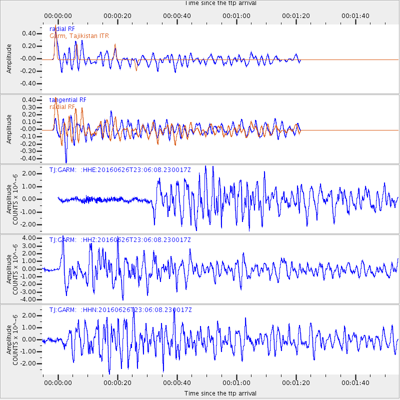
Signal To Noise
| Channel | StoN | STA | LTA |
| TJ:GARM: :HHZ:20160626T23:06:08.230017Z | 14.705133 | 1.7513121E-6 | 1.1909529E-7 |
| TJ:GARM: :HHN:20160626T23:06:08.230017Z | 3.3190956 | 4.3039017E-7 | 1.2967091E-7 |
| TJ:GARM: :HHE:20160626T23:06:08.230017Z | 7.4351635 | 8.392098E-7 | 1.1287039E-7 |
| Arrivals |
| Ps | 4.6 SECOND |
| PpPs | 17 SECOND |
| PsPs/PpSs | 22 SECOND |


