You are here: Home > Network List > US - United States National Seismic Network Stations List
> Station WUAZ Wupatki, Arizona, USA > Earthquake Result Viewer
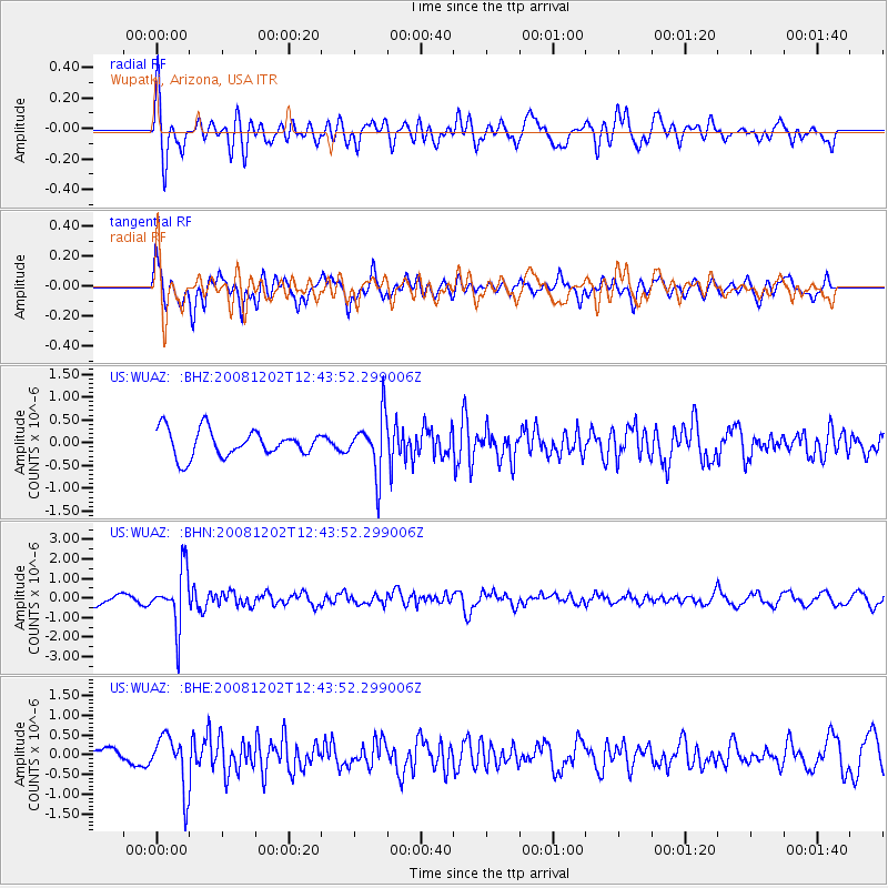
WUAZ Wupatki, Arizona, USA - Earthquake Result Viewer
*The percent match for this event was below the threshold and hence no stack was calculated.
| Earthquake location: |
Mariana Islands |
| Earthquake latitude/longitude: |
19.1/145.8 |
| Earthquake time(UTC): |
2008/12/02 (337) 12:31:43 GMT |
| Earthquake Depth: |
137 km |
| Earthquake Magnitude: |
5.9 MB, 5.9 MW, 5.9 MW |
| Earthquake Catalog/Contributor: |
WHDF/NEIC |
|
| Network: |
US United States National Seismic Network |
| Station: |
WUAZ Wupatki, Arizona, USA |
| Lat/Lon: |
35.52 N/111.37 W |
| Elevation: |
1592 m |
|
| Distance: |
89.1 deg |
| Az: |
52.691 deg |
| Baz: |
292.791 deg |
| Ray Param: |
$rayparam |
*The percent match for this event was below the threshold and hence was not used in the summary stack. |
|
| Radial Match: |
76.48578 % |
| Radial Bump: |
400 |
| Transverse Match: |
63.838974 % |
| Transverse Bump: |
400 |
| SOD ConfigId: |
2658 |
| Insert Time: |
2010-03-05 04:56:26.116 +0000 |
| GWidth: |
2.5 |
| Max Bumps: |
400 |
| Tol: |
0.001 |
|
Signal To Noise
| Channel | StoN | STA | LTA |
| US:WUAZ: :BHN:20081202T12:43:52.299006Z | 5.933718 | 1.4189851E-6 | 2.3913927E-7 |
| US:WUAZ: :BHE:20081202T12:43:52.299006Z | 3.047923 | 6.791264E-7 | 2.2281613E-7 |
| US:WUAZ: :BHZ:20081202T12:43:52.299006Z | 2.1285338 | 6.2178265E-7 | 2.921178E-7 |
| Arrivals |
| Ps | |
| PpPs | |
| PsPs/PpSs | |


