You are here: Home > Network List > AV - Alaska Volcano Observatory Stations List
> Station MAPS Pakushin Southeast, Makushin Volcano, Alaska > Earthquake Result Viewer
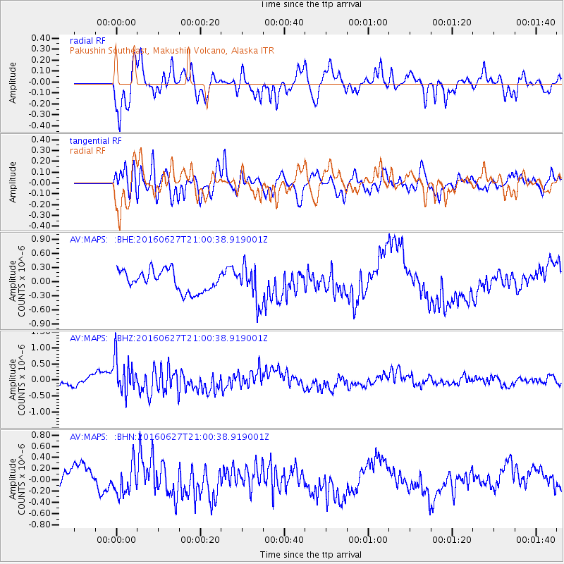
MAPS Pakushin Southeast, Makushin Volcano, Alaska - Earthquake Result Viewer
*The percent match for this event was below the threshold and hence no stack was calculated.
| Earthquake location: |
Oaxaca, Mexico |
| Earthquake latitude/longitude: |
16.6/-97.8 |
| Earthquake time(UTC): |
2016/06/27 (179) 20:50:34 GMT |
| Earthquake Depth: |
19 km |
| Earthquake Magnitude: |
5.7 MWW, 5.5 MWB |
| Earthquake Catalog/Contributor: |
NEIC PDE/NEIC COMCAT |
|
| Network: |
AV Alaska Volcano Observatory |
| Station: |
MAPS Pakushin Southeast, Makushin Volcano, Alaska |
| Lat/Lon: |
53.81 N/166.94 W |
| Elevation: |
333 m |
|
| Distance: |
64.5 deg |
| Az: |
322.118 deg |
| Baz: |
96.833 deg |
| Ray Param: |
$rayparam |
*The percent match for this event was below the threshold and hence was not used in the summary stack. |
|
| Radial Match: |
59.281784 % |
| Radial Bump: |
400 |
| Transverse Match: |
53.662056 % |
| Transverse Bump: |
400 |
| SOD ConfigId: |
11737051 |
| Insert Time: |
2019-04-24 23:59:07.599 +0000 |
| GWidth: |
2.5 |
| Max Bumps: |
400 |
| Tol: |
0.001 |
|
Signal To Noise
| Channel | StoN | STA | LTA |
| AV:MAPS: :BHZ:20160627T21:00:38.919001Z | 3.9586527 | 5.8963394E-7 | 1.4894813E-7 |
| AV:MAPS: :BHN:20160627T21:00:38.919001Z | 1.2671046 | 2.5598868E-7 | 2.0202648E-7 |
| AV:MAPS: :BHE:20160627T21:00:38.919001Z | 1.8376662 | 4.0278044E-7 | 2.1918044E-7 |
| Arrivals |
| Ps | |
| PpPs | |
| PsPs/PpSs | |


