You are here: Home > Network List > CN - Canadian National Seismograph Network Stations List
> Station A61 Sainte Mathilde, QC, CA > Earthquake Result Viewer
A61 Sainte Mathilde, QC, CA - Earthquake Result Viewer
| Earthquake location: |
Oaxaca, Mexico |
| Earthquake latitude/longitude: |
16.6/-97.8 |
| Earthquake time(UTC): |
2016/06/27 (179) 20:50:34 GMT |
| Earthquake Depth: |
19 km |
| Earthquake Magnitude: |
5.7 MWW, 5.5 MWB |
| Earthquake Catalog/Contributor: |
NEIC PDE/NEIC COMCAT |
|
| Network: |
CN Canadian National Seismograph Network |
| Station: |
A61 Sainte Mathilde, QC, CA |
| Lat/Lon: |
47.69 N/70.09 W |
| Elevation: |
380 m |
|
| Distance: |
38.5 deg |
| Az: |
30.328 deg |
| Baz: |
225.791 deg |
| Ray Param: |
0.0754877 |
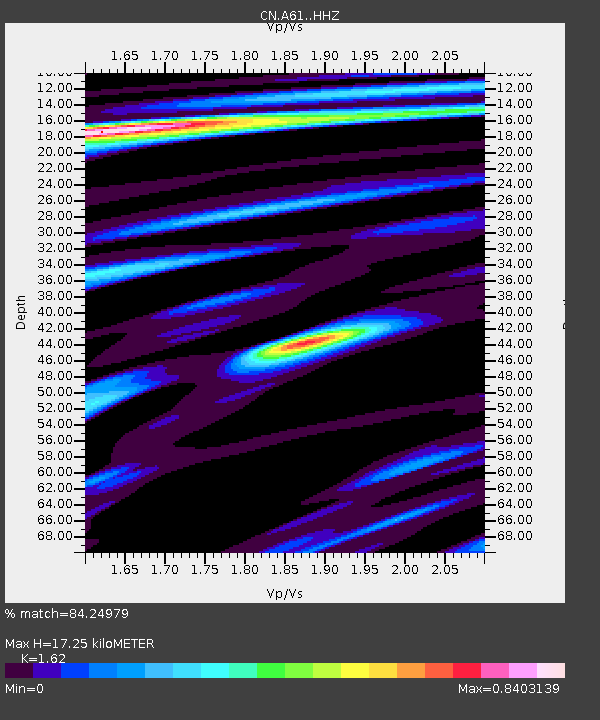
| Estimated Moho Depth: |
17.25 km |
| Estimated Crust Vp/Vs: |
1.62 |
| Assumed Crust Vp: |
6.61 km/s |
| Estimated Crust Vs: |
4.08 km/s |
| Estimated Crust Poisson's Ratio: |
0.19 |
|
| Radial Match: |
84.24979 % |
| Radial Bump: |
358 |
| Transverse Match: |
65.53798 % |
| Transverse Bump: |
400 |
| SOD ConfigId: |
11737051 |
| Insert Time: |
2019-04-24 23:59:50.532 +0000 |
| GWidth: |
2.5 |
| Max Bumps: |
400 |
| Tol: |
0.001 |
|

Signal To Noise
| Channel | StoN | STA | LTA |
| CN:A61: :HHZ:20160627T20:57:25.239985Z | 9.644363 | 6.2325523E-7 | 6.4623784E-8 |
| CN:A61: :HHN:20160627T20:57:25.239985Z | 3.6704009 | 2.7363606E-7 | 7.455209E-8 |
| CN:A61: :HHE:20160627T20:57:25.239985Z | 3.990894 | 2.5298488E-7 | 6.339053E-8 |
| Arrivals |
| Ps | 1.8 SECOND |
| PpPs | 6.3 SECOND |
| PsPs/PpSs | 8.0 SECOND |


