You are here: Home > Network List > CN - Canadian National Seismograph Network Stations List
> Station PNT Penticton, BC, CA > Earthquake Result Viewer
PNT Penticton, BC, CA - Earthquake Result Viewer
| Earthquake location: |
Oaxaca, Mexico |
| Earthquake latitude/longitude: |
16.6/-97.8 |
| Earthquake time(UTC): |
2016/06/27 (179) 20:50:34 GMT |
| Earthquake Depth: |
19 km |
| Earthquake Magnitude: |
5.7 MWW, 5.5 MWB |
| Earthquake Catalog/Contributor: |
NEIC PDE/NEIC COMCAT |
|
| Network: |
CN Canadian National Seismograph Network |
| Station: |
PNT Penticton, BC, CA |
| Lat/Lon: |
49.32 N/119.63 W |
| Elevation: |
531 m |
|
| Distance: |
37.2 deg |
| Az: |
336.292 deg |
| Baz: |
143.893 deg |
| Ray Param: |
0.07626671 |
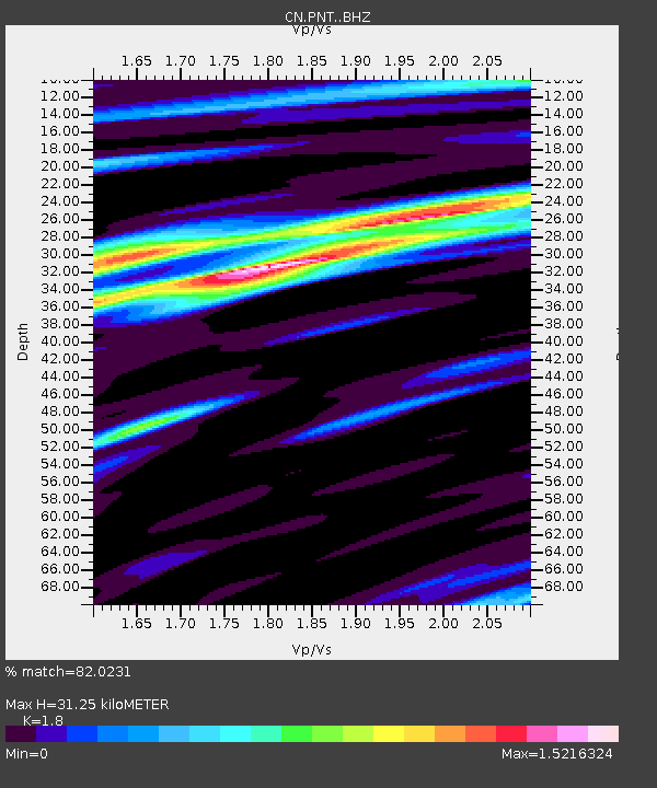
| Estimated Moho Depth: |
31.25 km |
| Estimated Crust Vp/Vs: |
1.80 |
| Assumed Crust Vp: |
6.419 km/s |
| Estimated Crust Vs: |
3.566 km/s |
| Estimated Crust Poisson's Ratio: |
0.28 |
|
| Radial Match: |
82.0231 % |
| Radial Bump: |
400 |
| Transverse Match: |
70.223785 % |
| Transverse Bump: |
400 |
| SOD ConfigId: |
11737051 |
| Insert Time: |
2019-04-25 00:00:23.672 +0000 |
| GWidth: |
2.5 |
| Max Bumps: |
400 |
| Tol: |
0.001 |
|

Signal To Noise
| Channel | StoN | STA | LTA |
| CN:PNT: :BHZ:20160627T20:57:13.749995Z | 9.284693 | 8.6885973E-7 | 9.357981E-8 |
| CN:PNT: :BHN:20160627T20:57:13.749995Z | 7.489241 | 4.856991E-7 | 6.485291E-8 |
| CN:PNT: :BHE:20160627T20:57:13.749995Z | 3.9500716 | 3.189041E-7 | 8.0733756E-8 |
| Arrivals |
| Ps | 4.2 SECOND |
| PpPs | 13 SECOND |
| PsPs/PpSs | 17 SECOND |


