You are here: Home > Network List > N4 - Central and EAstern US Network Stations List
> Station M63A Gales Ferry, CT, USA > Earthquake Result Viewer
M63A Gales Ferry, CT, USA - Earthquake Result Viewer
| Earthquake location: |
Oaxaca, Mexico |
| Earthquake latitude/longitude: |
16.6/-97.8 |
| Earthquake time(UTC): |
2016/06/27 (179) 20:50:34 GMT |
| Earthquake Depth: |
19 km |
| Earthquake Magnitude: |
5.7 MWW, 5.5 MWB |
| Earthquake Catalog/Contributor: |
NEIC PDE/NEIC COMCAT |
|
| Network: |
N4 Central and EAstern US Network |
| Station: |
M63A Gales Ferry, CT, USA |
| Lat/Lon: |
41.40 N/72.05 W |
| Elevation: |
44 m |
|
| Distance: |
33.3 deg |
| Az: |
36.651 deg |
| Baz: |
229.552 deg |
| Ray Param: |
0.078274384 |
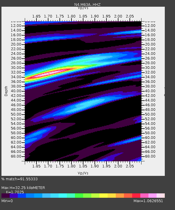
| Estimated Moho Depth: |
32.25 km |
| Estimated Crust Vp/Vs: |
1.70 |
| Assumed Crust Vp: |
6.472 km/s |
| Estimated Crust Vs: |
3.801 km/s |
| Estimated Crust Poisson's Ratio: |
0.24 |
|
| Radial Match: |
91.55333 % |
| Radial Bump: |
242 |
| Transverse Match: |
67.06726 % |
| Transverse Bump: |
400 |
| SOD ConfigId: |
11737051 |
| Insert Time: |
2019-04-25 00:02:08.401 +0000 |
| GWidth: |
2.5 |
| Max Bumps: |
400 |
| Tol: |
0.001 |
|

Signal To Noise
| Channel | StoN | STA | LTA |
| N4:M63A: :HHZ:20160627T20:56:40.130Z | 10.169554 | 1.1915092E-6 | 1.17164355E-7 |
| N4:M63A: :HHN:20160627T20:56:40.130Z | 5.055077 | 4.5561714E-7 | 9.01306E-8 |
| N4:M63A: :HHE:20160627T20:56:40.130Z | 7.5631013 | 6.293847E-7 | 8.3217806E-8 |
| Arrivals |
| Ps | 3.8 SECOND |
| PpPs | 12 SECOND |
| PsPs/PpSs | 16 SECOND |


