You are here: Home > Network List > RV - Regional Alberta Seismic Observatory for Earthquake Studies Network Stations List
> Station HILA High Level, AB > Earthquake Result Viewer
HILA High Level, AB - Earthquake Result Viewer
| Earthquake location: |
Oaxaca, Mexico |
| Earthquake latitude/longitude: |
16.6/-97.8 |
| Earthquake time(UTC): |
2016/06/27 (179) 20:50:34 GMT |
| Earthquake Depth: |
19 km |
| Earthquake Magnitude: |
5.7 MWW, 5.5 MWB |
| Earthquake Catalog/Contributor: |
NEIC PDE/NEIC COMCAT |
|
| Network: |
RV Regional Alberta Seismic Observatory for Earthquake Studies Network |
| Station: |
HILA High Level, AB |
| Lat/Lon: |
58.56 N/117.02 W |
| Elevation: |
329 m |
|
| Distance: |
44.3 deg |
| Az: |
345.713 deg |
| Baz: |
153.162 deg |
| Ray Param: |
0.07200127 |
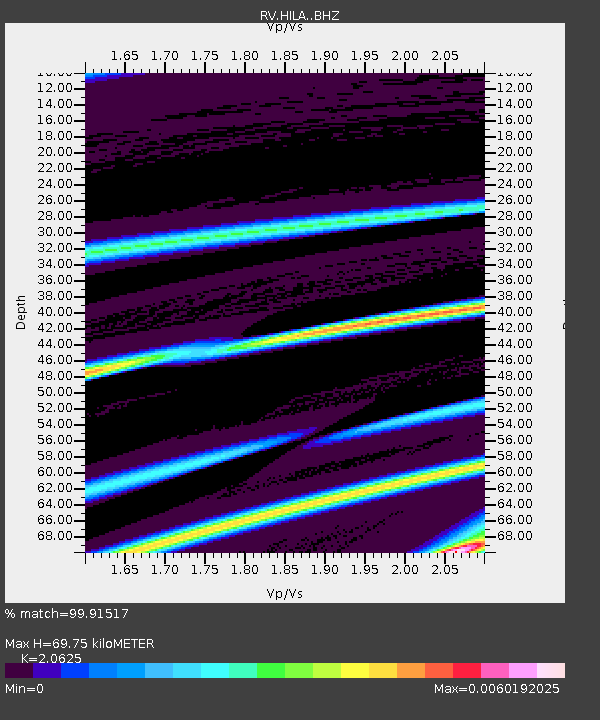
| Estimated Moho Depth: |
69.75 km |
| Estimated Crust Vp/Vs: |
2.06 |
| Assumed Crust Vp: |
6.498 km/s |
| Estimated Crust Vs: |
3.15 km/s |
| Estimated Crust Poisson's Ratio: |
0.35 |
|
| Radial Match: |
99.91517 % |
| Radial Bump: |
18 |
| Transverse Match: |
66.59247 % |
| Transverse Bump: |
283 |
| SOD ConfigId: |
11737051 |
| Insert Time: |
2019-04-25 00:02:49.360 +0000 |
| GWidth: |
2.5 |
| Max Bumps: |
400 |
| Tol: |
0.001 |
|

Signal To Noise
| Channel | StoN | STA | LTA |
| RV:HILA: :BHZ:20160627T20:58:12.274989Z | 1.1923158 | 3.763351E-4 | 3.1563375E-4 |
| RV:HILA: :BHN:20160627T20:58:12.274989Z | 1.1839303 | 4.835519E-4 | 4.0842936E-4 |
| RV:HILA: :BHE:20160627T20:58:12.274989Z | 1.2124534 | 2.6638433E-4 | 2.1970687E-4 |
| Arrivals |
| Ps | 12 SECOND |
| PpPs | 31 SECOND |
| PsPs/PpSs | 43 SECOND |


