You are here: Home > Network List > TA - USArray Transportable Network (new EarthScope stations) Stations List
> Station D23K Nanushuk River, AK USA > Earthquake Result Viewer
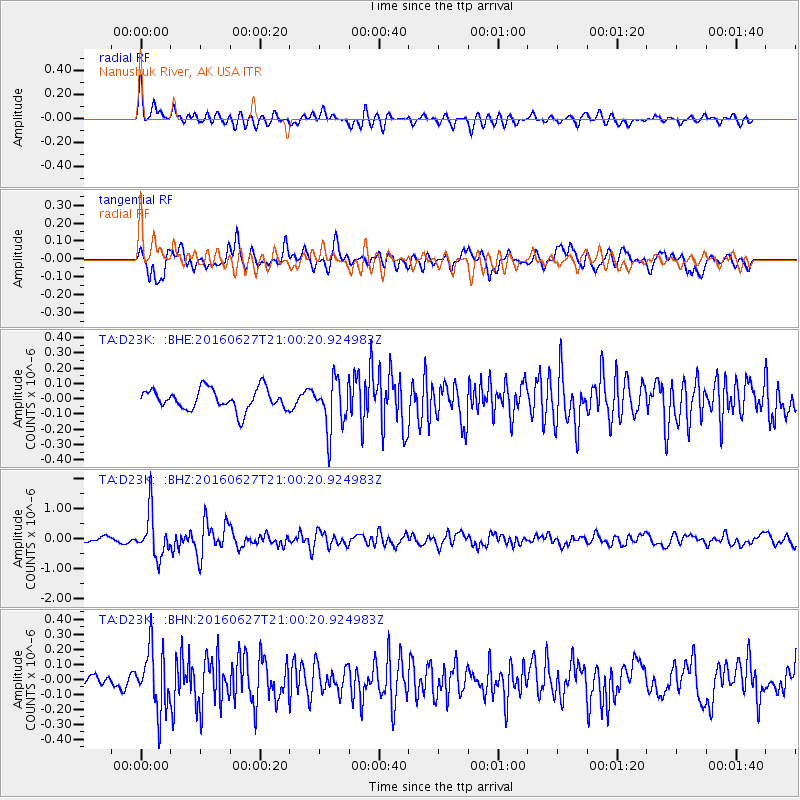
D23K Nanushuk River, AK USA - Earthquake Result Viewer
*The percent match for this event was below the threshold and hence no stack was calculated.
| Earthquake location: |
Oaxaca, Mexico |
| Earthquake latitude/longitude: |
16.6/-97.8 |
| Earthquake time(UTC): |
2016/06/27 (179) 20:50:34 GMT |
| Earthquake Depth: |
19 km |
| Earthquake Magnitude: |
5.7 MWW, 5.5 MWB |
| Earthquake Catalog/Contributor: |
NEIC PDE/NEIC COMCAT |
|
| Network: |
TA USArray Transportable Network (new EarthScope stations) |
| Station: |
D23K Nanushuk River, AK USA |
| Lat/Lon: |
68.97 N/150.68 W |
| Elevation: |
406 m |
|
| Distance: |
61.7 deg |
| Az: |
340.934 deg |
| Baz: |
119.808 deg |
| Ray Param: |
$rayparam |
*The percent match for this event was below the threshold and hence was not used in the summary stack. |
|
| Radial Match: |
74.014 % |
| Radial Bump: |
400 |
| Transverse Match: |
75.0482 % |
| Transverse Bump: |
400 |
| SOD ConfigId: |
11737051 |
| Insert Time: |
2019-04-25 00:03:05.647 +0000 |
| GWidth: |
2.5 |
| Max Bumps: |
400 |
| Tol: |
0.001 |
|
Signal To Noise
| Channel | StoN | STA | LTA |
| TA:D23K: :BHZ:20160627T21:00:20.924983Z | 9.737464 | 7.311953E-7 | 7.509094E-8 |
| TA:D23K: :BHN:20160627T21:00:20.924983Z | 3.7948089 | 2.0080522E-7 | 5.2915766E-8 |
| TA:D23K: :BHE:20160627T21:00:20.924983Z | 2.3723717 | 1.6325355E-7 | 6.881449E-8 |
| Arrivals |
| Ps | |
| PpPs | |
| PsPs/PpSs | |


