You are here: Home > Network List > TA - USArray Transportable Network (new EarthScope stations) Stations List
> Station J26L Joseph Creek, AK, USA > Earthquake Result Viewer
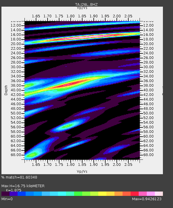
J26L Joseph Creek, AK, USA - Earthquake Result Viewer
| Earthquake location: |
Oaxaca, Mexico |
| Earthquake latitude/longitude: |
16.6/-97.8 |
| Earthquake time(UTC): |
2016/06/27 (179) 20:50:34 GMT |
| Earthquake Depth: |
19 km |
| Earthquake Magnitude: |
5.7 MWW, 5.5 MWB |
| Earthquake Catalog/Contributor: |
NEIC PDE/NEIC COMCAT |
|
| Network: |
TA USArray Transportable Network (new EarthScope stations) |
| Station: |
J26L Joseph Creek, AK, USA |
| Lat/Lon: |
64.50 N/143.56 W |
| Elevation: |
1144 m |
|
| Distance: |
57.0 deg |
| Az: |
338.302 deg |
| Baz: |
125.003 deg |
| Ray Param: |
0.063779585 |
| Estimated Moho Depth: |
16.75 km |
| Estimated Crust Vp/Vs: |
1.88 |
| Assumed Crust Vp: |
6.566 km/s |
| Estimated Crust Vs: |
3.502 km/s |
| Estimated Crust Poisson's Ratio: |
0.30 |
|
| Radial Match: |
81.60348 % |
| Radial Bump: |
400 |
| Transverse Match: |
82.418465 % |
| Transverse Bump: |
400 |
| SOD ConfigId: |
11737051 |
| Insert Time: |
2019-04-25 00:03:23.451 +0000 |
| GWidth: |
2.5 |
| Max Bumps: |
400 |
| Tol: |
0.001 |
|

Signal To Noise
| Channel | StoN | STA | LTA |
| TA:J26L: :BHZ:20160627T20:59:47.90002Z | 14.8083515 | 8.627799E-7 | 5.8263065E-8 |
| TA:J26L: :BHN:20160627T20:59:47.90002Z | 3.7678344 | 1.8575332E-7 | 4.9299757E-8 |
| TA:J26L: :BHE:20160627T20:59:47.90002Z | 6.308411 | 3.6598473E-7 | 5.8015356E-8 |
| Arrivals |
| Ps | 2.3 SECOND |
| PpPs | 7.0 SECOND |
| PsPs/PpSs | 9.3 SECOND |


