You are here: Home > Network List > US - United States National Seismic Network Stations List
> Station AMTX Amarillo, Texas, USA > Earthquake Result Viewer
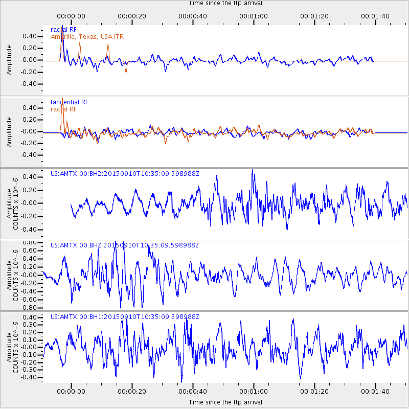
AMTX Amarillo, Texas, USA - Earthquake Result Viewer
*The percent match for this event was below the threshold and hence no stack was calculated.
| Earthquake location: |
Fox Islands, Aleutian Islands |
| Earthquake latitude/longitude: |
52.2/-169.6 |
| Earthquake time(UTC): |
2015/09/10 (253) 10:26:47 GMT |
| Earthquake Depth: |
38 km |
| Earthquake Magnitude: |
5.9 MWP, 5.9 MI |
| Earthquake Catalog/Contributor: |
NEIC PDE/NEIC COMCAT |
|
| Network: |
US United States National Seismic Network |
| Station: |
AMTX Amarillo, Texas, USA |
| Lat/Lon: |
34.53 N/101.41 W |
| Elevation: |
1010 m |
|
| Distance: |
50.7 deg |
| Az: |
82.143 deg |
| Baz: |
312.345 deg |
| Ray Param: |
$rayparam |
*The percent match for this event was below the threshold and hence was not used in the summary stack. |
|
| Radial Match: |
67.15658 % |
| Radial Bump: |
400 |
| Transverse Match: |
45.516888 % |
| Transverse Bump: |
400 |
| SOD ConfigId: |
1156111 |
| Insert Time: |
2015-09-24 10:41:25.808 +0000 |
| GWidth: |
2.5 |
| Max Bumps: |
400 |
| Tol: |
0.001 |
|
Signal To Noise
| Channel | StoN | STA | LTA |
| US:AMTX:00:BHZ:20150910T10:35:09.598988Z | 3.68618 | 2.485539E-7 | 6.742858E-8 |
| US:AMTX:00:BH1:20150910T10:35:09.598988Z | 1.4078666 | 1.4979773E-7 | 1.0640051E-7 |
| US:AMTX:00:BH2:20150910T10:35:09.598988Z | 1.276235 | 1.2445672E-7 | 9.751865E-8 |
| Arrivals |
| Ps | |
| PpPs | |
| PsPs/PpSs | |


