You are here: Home > Network List > TA - USArray Transportable Network (new EarthScope stations) Stations List
> Station D25K Kavik River, AK, USA > Earthquake Result Viewer
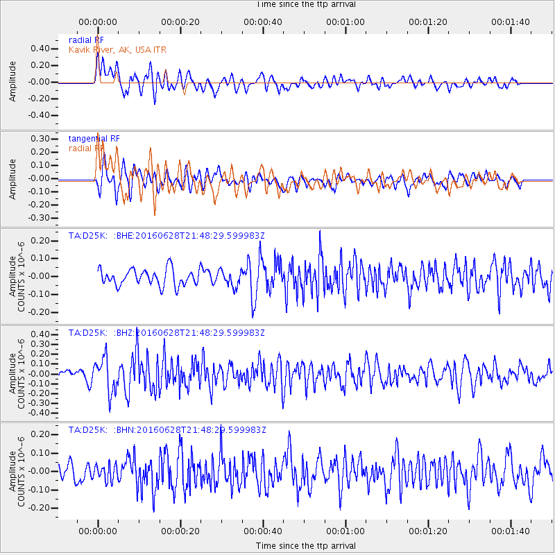
D25K Kavik River, AK, USA - Earthquake Result Viewer
*The percent match for this event was below the threshold and hence no stack was calculated.
| Earthquake location: |
Tajikistan-Xinjiang Border Reg. |
| Earthquake latitude/longitude: |
39.5/73.3 |
| Earthquake time(UTC): |
2016/06/28 (180) 21:38:04 GMT |
| Earthquake Depth: |
14 km |
| Earthquake Magnitude: |
5.5 MWW, 5.4 MWB, 5.5 MWC |
| Earthquake Catalog/Contributor: |
NEIC PDE/NEIC COMCAT |
|
| Network: |
TA USArray Transportable Network (new EarthScope stations) |
| Station: |
D25K Kavik River, AK, USA |
| Lat/Lon: |
69.32 N/146.38 W |
| Elevation: |
770 m |
|
| Distance: |
67.6 deg |
| Az: |
14.204 deg |
| Baz: |
327.676 deg |
| Ray Param: |
$rayparam |
*The percent match for this event was below the threshold and hence was not used in the summary stack. |
|
| Radial Match: |
75.35311 % |
| Radial Bump: |
400 |
| Transverse Match: |
69.98635 % |
| Transverse Bump: |
400 |
| SOD ConfigId: |
11737051 |
| Insert Time: |
2019-04-25 00:10:22.374 +0000 |
| GWidth: |
2.5 |
| Max Bumps: |
400 |
| Tol: |
0.001 |
|
Signal To Noise
| Channel | StoN | STA | LTA |
| TA:D25K: :BHZ:20160628T21:48:29.599983Z | 3.8676884 | 1.7500535E-7 | 4.5248047E-8 |
| TA:D25K: :BHN:20160628T21:48:29.599983Z | 0.89305943 | 4.21365E-8 | 4.718219E-8 |
| TA:D25K: :BHE:20160628T21:48:29.599983Z | 0.97320193 | 4.4243848E-8 | 4.5462148E-8 |
| Arrivals |
| Ps | |
| PpPs | |
| PsPs/PpSs | |


