You are here: Home > Network List > UU - University of Utah Regional Network Stations List
> Station LIUT Lila Canyon, UT, USA > Earthquake Result Viewer
LIUT Lila Canyon, UT, USA - Earthquake Result Viewer
| Earthquake location: |
Fox Islands, Aleutian Islands |
| Earthquake latitude/longitude: |
52.2/-169.6 |
| Earthquake time(UTC): |
2015/09/10 (253) 10:26:47 GMT |
| Earthquake Depth: |
38 km |
| Earthquake Magnitude: |
5.9 MWP, 5.9 MI |
| Earthquake Catalog/Contributor: |
NEIC PDE/NEIC COMCAT |
|
| Network: |
UU University of Utah Regional Network |
| Station: |
LIUT Lila Canyon, UT, USA |
| Lat/Lon: |
39.42 N/110.33 W |
| Elevation: |
2178 m |
|
| Distance: |
42.1 deg |
| Az: |
83.343 deg |
| Baz: |
307.823 deg |
| Ray Param: |
0.07330069 |
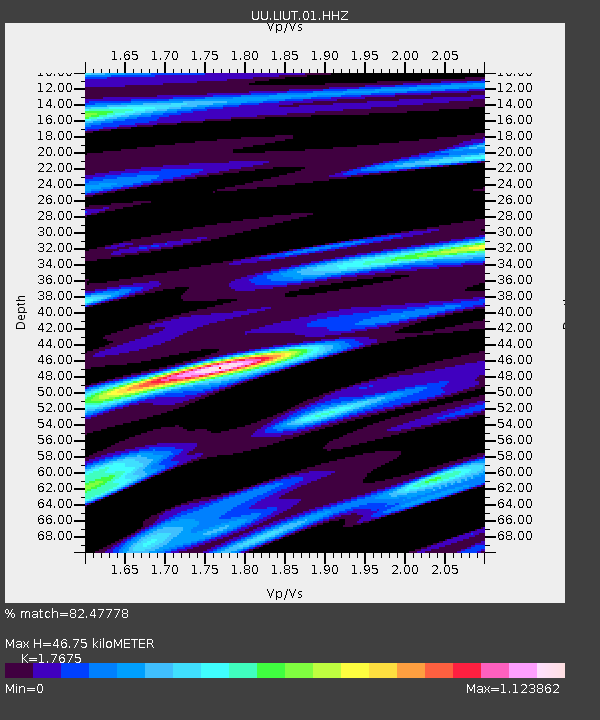
| Estimated Moho Depth: |
46.75 km |
| Estimated Crust Vp/Vs: |
1.77 |
| Assumed Crust Vp: |
6.207 km/s |
| Estimated Crust Vs: |
3.512 km/s |
| Estimated Crust Poisson's Ratio: |
0.26 |
|
| Radial Match: |
82.47778 % |
| Radial Bump: |
400 |
| Transverse Match: |
62.24952 % |
| Transverse Bump: |
400 |
| SOD ConfigId: |
1156111 |
| Insert Time: |
2015-09-24 10:44:17.739 +0000 |
| GWidth: |
2.5 |
| Max Bumps: |
400 |
| Tol: |
0.001 |
|

Signal To Noise
| Channel | StoN | STA | LTA |
| UU:LIUT:01:HHZ:20150910T10:34:05.270009Z | 1.8943185 | 6.547885E-9 | 3.4565915E-9 |
| UU:LIUT:01:HHN:20150910T10:34:05.270009Z | 0.957444 | 2.356346E-9 | 2.4610796E-9 |
| UU:LIUT:01:HHE:20150910T10:34:05.270009Z | 1.6438638 | 4.6426805E-9 | 2.8242488E-9 |
| Arrivals |
| Ps | 6.2 SECOND |
| PpPs | 20 SECOND |
| PsPs/PpSs | 26 SECOND |


