You are here: Home > Network List > TA - USArray Transportable Network (new EarthScope stations) Stations List
> Station K20K Telida, AK, USA > Earthquake Result Viewer
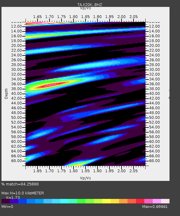
K20K Telida, AK, USA - Earthquake Result Viewer
| Earthquake location: |
Vanuatu Islands |
| Earthquake latitude/longitude: |
-14.6/166.5 |
| Earthquake time(UTC): |
2016/06/28 (180) 22:46:46 GMT |
| Earthquake Depth: |
10 km |
| Earthquake Magnitude: |
5.5 MB |
| Earthquake Catalog/Contributor: |
NEIC PDE/NEIC COMCAT |
|
| Network: |
TA USArray Transportable Network (new EarthScope stations) |
| Station: |
K20K Telida, AK, USA |
| Lat/Lon: |
63.36 N/154.07 W |
| Elevation: |
548 m |
|
| Distance: |
83.5 deg |
| Az: |
16.743 deg |
| Baz: |
218.212 deg |
| Ray Param: |
0.046157554 |
| Estimated Moho Depth: |
10.0 km |
| Estimated Crust Vp/Vs: |
1.73 |
| Assumed Crust Vp: |
6.438 km/s |
| Estimated Crust Vs: |
3.722 km/s |
| Estimated Crust Poisson's Ratio: |
0.25 |
|
| Radial Match: |
84.25988 % |
| Radial Bump: |
400 |
| Transverse Match: |
68.86733 % |
| Transverse Bump: |
400 |
| SOD ConfigId: |
11737051 |
| Insert Time: |
2019-04-25 00:16:47.172 +0000 |
| GWidth: |
2.5 |
| Max Bumps: |
400 |
| Tol: |
0.001 |
|

Signal To Noise
| Channel | StoN | STA | LTA |
| TA:K20K: :BHZ:20160628T22:58:43.349995Z | 17.035055 | 5.49335E-7 | 3.224733E-8 |
| TA:K20K: :BHN:20160628T22:58:43.349995Z | 2.859342 | 1.2041575E-7 | 4.2113093E-8 |
| TA:K20K: :BHE:20160628T22:58:43.349995Z | 2.9766 | 1.3080661E-7 | 4.394498E-8 |
| Arrivals |
| Ps | 1.2 SECOND |
| PpPs | 4.1 SECOND |
| PsPs/PpSs | 5.3 SECOND |


