You are here: Home > Network List > TA - USArray Transportable Network (new EarthScope stations) Stations List
> Station M22K Willow, AK, USA > Earthquake Result Viewer
M22K Willow, AK, USA - Earthquake Result Viewer
| Earthquake location: |
Vanuatu Islands |
| Earthquake latitude/longitude: |
-14.6/166.5 |
| Earthquake time(UTC): |
2016/06/28 (180) 22:46:46 GMT |
| Earthquake Depth: |
10 km |
| Earthquake Magnitude: |
5.5 MB |
| Earthquake Catalog/Contributor: |
NEIC PDE/NEIC COMCAT |
|
| Network: |
TA USArray Transportable Network (new EarthScope stations) |
| Station: |
M22K Willow, AK, USA |
| Lat/Lon: |
61.75 N/150.12 W |
| Elevation: |
57 m |
|
| Distance: |
83.4 deg |
| Az: |
19.195 deg |
| Baz: |
221.992 deg |
| Ray Param: |
0.046194743 |
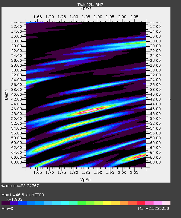
| Estimated Moho Depth: |
46.5 km |
| Estimated Crust Vp/Vs: |
1.87 |
| Assumed Crust Vp: |
6.302 km/s |
| Estimated Crust Vs: |
3.379 km/s |
| Estimated Crust Poisson's Ratio: |
0.30 |
|
| Radial Match: |
83.34767 % |
| Radial Bump: |
400 |
| Transverse Match: |
76.465965 % |
| Transverse Bump: |
400 |
| SOD ConfigId: |
11737051 |
| Insert Time: |
2019-04-25 00:16:53.071 +0000 |
| GWidth: |
2.5 |
| Max Bumps: |
400 |
| Tol: |
0.001 |
|

Signal To Noise
| Channel | StoN | STA | LTA |
| TA:M22K: :BHZ:20160628T22:58:43.099019Z | 4.8380704 | 8.8023893E-7 | 1.819401E-7 |
| TA:M22K: :BHN:20160628T22:58:43.099019Z | 2.5672667 | 4.7187345E-7 | 1.8380383E-7 |
| TA:M22K: :BHE:20160628T22:58:43.099019Z | 2.3185468 | 4.0976752E-7 | 1.7673464E-7 |
| Arrivals |
| Ps | 6.5 SECOND |
| PpPs | 21 SECOND |
| PsPs/PpSs | 27 SECOND |


