You are here: Home > Network List > TA - USArray Transportable Network (new EarthScope stations) Stations List
> Station P17K Kvichak River, AK, USA > Earthquake Result Viewer
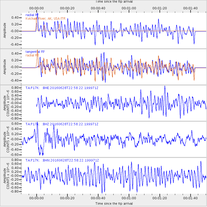
P17K Kvichak River, AK, USA - Earthquake Result Viewer
*The percent match for this event was below the threshold and hence no stack was calculated.
| Earthquake location: |
Vanuatu Islands |
| Earthquake latitude/longitude: |
-14.6/166.5 |
| Earthquake time(UTC): |
2016/06/28 (180) 22:46:46 GMT |
| Earthquake Depth: |
10 km |
| Earthquake Magnitude: |
5.5 MB |
| Earthquake Catalog/Contributor: |
NEIC PDE/NEIC COMCAT |
|
| Network: |
TA USArray Transportable Network (new EarthScope stations) |
| Station: |
P17K Kvichak River, AK, USA |
| Lat/Lon: |
59.20 N/156.44 W |
| Elevation: |
91 m |
|
| Distance: |
79.5 deg |
| Az: |
18.38 deg |
| Baz: |
216.379 deg |
| Ray Param: |
$rayparam |
*The percent match for this event was below the threshold and hence was not used in the summary stack. |
|
| Radial Match: |
66.83649 % |
| Radial Bump: |
400 |
| Transverse Match: |
62.373825 % |
| Transverse Bump: |
400 |
| SOD ConfigId: |
11737051 |
| Insert Time: |
2019-04-25 00:17:04.022 +0000 |
| GWidth: |
2.5 |
| Max Bumps: |
400 |
| Tol: |
0.001 |
|
Signal To Noise
| Channel | StoN | STA | LTA |
| TA:P17K: :BHZ:20160628T22:58:22.199971Z | 4.212519 | 4.0364966E-7 | 9.582144E-8 |
| TA:P17K: :BHN:20160628T22:58:22.199971Z | 1.8050783 | 2.6485148E-7 | 1.4672575E-7 |
| TA:P17K: :BHE:20160628T22:58:22.199971Z | 1.3370068 | 2.1013008E-7 | 1.5716456E-7 |
| Arrivals |
| Ps | |
| PpPs | |
| PsPs/PpSs | |


