You are here: Home > Network List > UW - Pacific Northwest Regional Seismic Network Stations List
> Station UMAT Pilot Rock, OR, USA > Earthquake Result Viewer
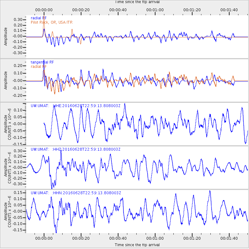
UMAT Pilot Rock, OR, USA - Earthquake Result Viewer
*The percent match for this event was below the threshold and hence no stack was calculated.
| Earthquake location: |
Vanuatu Islands |
| Earthquake latitude/longitude: |
-14.6/166.5 |
| Earthquake time(UTC): |
2016/06/28 (180) 22:46:46 GMT |
| Earthquake Depth: |
10 km |
| Earthquake Magnitude: |
5.5 MB |
| Earthquake Catalog/Contributor: |
NEIC PDE/NEIC COMCAT |
|
| Network: |
UW Pacific Northwest Regional Seismic Network |
| Station: |
UMAT Pilot Rock, OR, USA |
| Lat/Lon: |
45.29 N/118.96 W |
| Elevation: |
1318 m |
|
| Distance: |
89.7 deg |
| Az: |
42.866 deg |
| Baz: |
248.903 deg |
| Ray Param: |
$rayparam |
*The percent match for this event was below the threshold and hence was not used in the summary stack. |
|
| Radial Match: |
45.966236 % |
| Radial Bump: |
400 |
| Transverse Match: |
57.273983 % |
| Transverse Bump: |
400 |
| SOD ConfigId: |
11737051 |
| Insert Time: |
2019-04-25 00:17:35.793 +0000 |
| GWidth: |
2.5 |
| Max Bumps: |
400 |
| Tol: |
0.001 |
|
Signal To Noise
| Channel | StoN | STA | LTA |
| UW:UMAT: :HHZ:20160628T22:59:13.808003Z | 2.6359117 | 1.9648472E-7 | 7.454146E-8 |
| UW:UMAT: :HHN:20160628T22:59:13.808003Z | 0.819762 | 4.4971145E-8 | 5.485878E-8 |
| UW:UMAT: :HHE:20160628T22:59:13.808003Z | 0.99373275 | 7.246346E-8 | 7.292047E-8 |
| Arrivals |
| Ps | |
| PpPs | |
| PsPs/PpSs | |


