You are here: Home > Network List > US - United States National Seismic Network Stations List
> Station MSO Missoula, Montana, USA > Earthquake Result Viewer
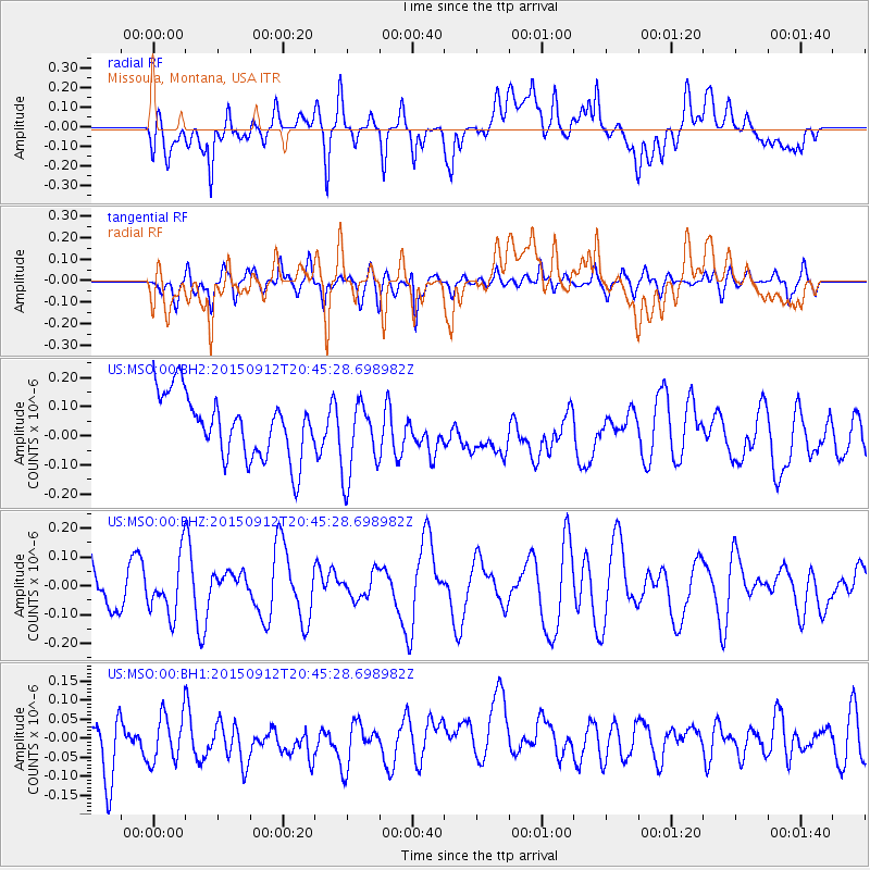
MSO Missoula, Montana, USA - Earthquake Result Viewer
*The percent match for this event was below the threshold and hence no stack was calculated.
| Earthquake location: |
South Of Kermadec Islands |
| Earthquake latitude/longitude: |
-32.5/-177.9 |
| Earthquake time(UTC): |
2015/09/12 (255) 20:32:25 GMT |
| Earthquake Depth: |
10 km |
| Earthquake Magnitude: |
5.7 MB |
| Earthquake Catalog/Contributor: |
NEIC PDE/NEIC COMCAT |
|
| Network: |
US United States National Seismic Network |
| Station: |
MSO Missoula, Montana, USA |
| Lat/Lon: |
46.83 N/113.94 W |
| Elevation: |
1264 m |
|
| Distance: |
97.7 deg |
| Az: |
38.513 deg |
| Baz: |
230.014 deg |
| Ray Param: |
$rayparam |
*The percent match for this event was below the threshold and hence was not used in the summary stack. |
|
| Radial Match: |
48.343426 % |
| Radial Bump: |
400 |
| Transverse Match: |
54.222824 % |
| Transverse Bump: |
388 |
| SOD ConfigId: |
1156111 |
| Insert Time: |
2015-09-26 20:57:57.737 +0000 |
| GWidth: |
2.5 |
| Max Bumps: |
400 |
| Tol: |
0.001 |
|
Signal To Noise
| Channel | StoN | STA | LTA |
| US:MSO:00:BHZ:20150912T20:45:28.698982Z | 1.6094061 | 9.782386E-8 | 6.078258E-8 |
| US:MSO:00:BH1:20150912T20:45:28.698982Z | 0.77658546 | 7.209652E-8 | 9.2837844E-8 |
| US:MSO:00:BH2:20150912T20:45:28.698982Z | 1.2602172 | 1.3389418E-7 | 1.0624691E-7 |
| Arrivals |
| Ps | |
| PpPs | |
| PsPs/PpSs | |


