You are here: Home > Network List > CI - Caltech Regional Seismic Network Stations List
> Station MPM Manuel Prospect Mine, California, USA > Earthquake Result Viewer
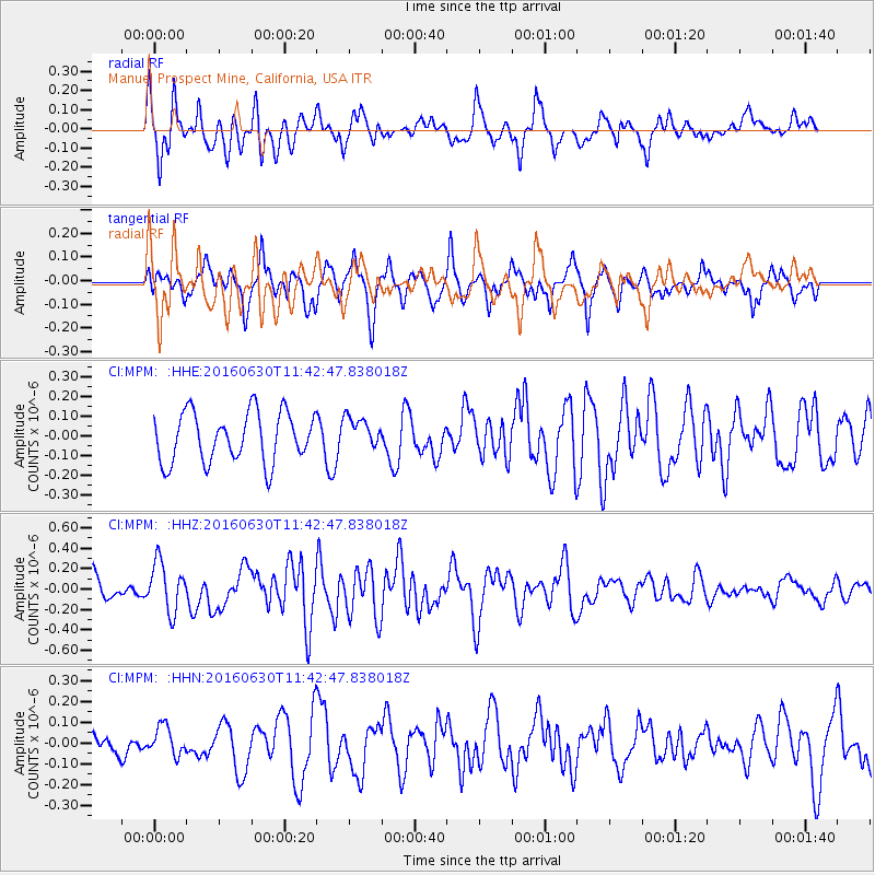
MPM Manuel Prospect Mine, California, USA - Earthquake Result Viewer
*The percent match for this event was below the threshold and hence no stack was calculated.
| Earthquake location: |
Vanuatu Islands |
| Earthquake latitude/longitude: |
-16.1/167.4 |
| Earthquake time(UTC): |
2016/06/30 (182) 11:30:34 GMT |
| Earthquake Depth: |
40 km |
| Earthquake Magnitude: |
5.8 MB |
| Earthquake Catalog/Contributor: |
NEIC PDE/NEIC COMCAT |
|
| Network: |
CI Caltech Regional Seismic Network |
| Station: |
MPM Manuel Prospect Mine, California, USA |
| Lat/Lon: |
36.06 N/117.49 W |
| Elevation: |
185 m |
|
| Distance: |
87.8 deg |
| Az: |
51.592 deg |
| Baz: |
248.38 deg |
| Ray Param: |
$rayparam |
*The percent match for this event was below the threshold and hence was not used in the summary stack. |
|
| Radial Match: |
65.1656 % |
| Radial Bump: |
400 |
| Transverse Match: |
64.30118 % |
| Transverse Bump: |
400 |
| SOD ConfigId: |
11737051 |
| Insert Time: |
2019-04-25 00:21:13.256 +0000 |
| GWidth: |
2.5 |
| Max Bumps: |
400 |
| Tol: |
0.001 |
|
Signal To Noise
| Channel | StoN | STA | LTA |
| CI:MPM: :HHZ:20160630T11:42:47.838018Z | 2.385571 | 2.4245958E-7 | 1.0163586E-7 |
| CI:MPM: :HHN:20160630T11:42:47.838018Z | 0.9060847 | 6.8385056E-8 | 7.5473146E-8 |
| CI:MPM: :HHE:20160630T11:42:47.838018Z | 0.5434653 | 6.880326E-8 | 1.2660101E-7 |
| Arrivals |
| Ps | |
| PpPs | |
| PsPs/PpSs | |


