You are here: Home > Network List > TA - USArray Transportable Network (new EarthScope stations) Stations List
> Station L19K White Mountain, AK, USA > Earthquake Result Viewer
L19K White Mountain, AK, USA - Earthquake Result Viewer
| Earthquake location: |
Vanuatu Islands |
| Earthquake latitude/longitude: |
-16.1/167.4 |
| Earthquake time(UTC): |
2016/06/30 (182) 11:30:34 GMT |
| Earthquake Depth: |
40 km |
| Earthquake Magnitude: |
5.8 MB |
| Earthquake Catalog/Contributor: |
NEIC PDE/NEIC COMCAT |
|
| Network: |
TA USArray Transportable Network (new EarthScope stations) |
| Station: |
L19K White Mountain, AK, USA |
| Lat/Lon: |
62.18 N/154.85 W |
| Elevation: |
650 m |
|
| Distance: |
83.5 deg |
| Az: |
16.793 deg |
| Baz: |
216.3 deg |
| Ray Param: |
0.046092488 |
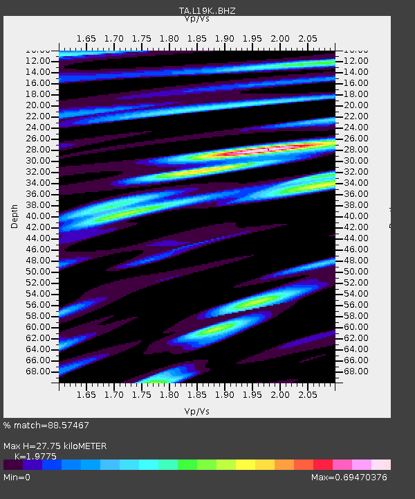
| Estimated Moho Depth: |
27.75 km |
| Estimated Crust Vp/Vs: |
1.98 |
| Assumed Crust Vp: |
6.438 km/s |
| Estimated Crust Vs: |
3.256 km/s |
| Estimated Crust Poisson's Ratio: |
0.33 |
|
| Radial Match: |
88.57467 % |
| Radial Bump: |
400 |
| Transverse Match: |
79.79603 % |
| Transverse Bump: |
400 |
| SOD ConfigId: |
11737051 |
| Insert Time: |
2019-04-25 00:23:32.159 +0000 |
| GWidth: |
2.5 |
| Max Bumps: |
400 |
| Tol: |
0.001 |
|

Signal To Noise
| Channel | StoN | STA | LTA |
| TA:L19K: :BHZ:20160630T11:42:26.700017Z | 9.514283 | 5.1269365E-7 | 5.3886733E-8 |
| TA:L19K: :BHN:20160630T11:42:26.700017Z | 4.295586 | 1.9686856E-7 | 4.583043E-8 |
| TA:L19K: :BHE:20160630T11:42:26.700017Z | 3.4494717 | 1.4916172E-7 | 4.32419E-8 |
| Arrivals |
| Ps | 4.3 SECOND |
| PpPs | 13 SECOND |
| PsPs/PpSs | 17 SECOND |


